
You are using an out of date browser. It may not display this or other websites correctly.
You should upgrade or use an alternative browser.
You should upgrade or use an alternative browser.
Australia Claremont Serial Killer, 1996-1997, Perth, Western Australia - #7 *ARREST*
- Thread starter Sillybilly
- Start date


- Status
- Not open for further replies.
meticulously
Former smartphone blogger
- Joined
- Oct 16, 2016
- Messages
- 1,671
- Reaction score
- 263
No not the jr / cg line . But other than that I'm waiting to see moreProfilers are not nutjobs. If they say SS is probably east, I believe them. Are you disputing the accuracy of the North / South line?
tapatalk
SM born approx 1972 .
I didn't meet him until a few yrs after lisa disappeared . (Definitely not a poi either)
tapatalk
So early 20's around SS
One of the main reasons the CSK hasn't been found is due to family and friends dismissing them without consideration
Jba , theres nothing to link mott with csk except for the line mark link .
Im not discounting it , but nobody except the nuttiest sleuths have claimed it is real over 36 years since lisa went .
It's still a link and a fact.
Not saying the CSK is the same person to do with Mott but could have a connection in some way.
With the little info the police have given out over the 20 years anything "new" that comes to light should be worth looking into a bit.
Why would SS be DIRECTLY east? The CG JR line is not exactly north south, its about 12.5 degrees from North/South.
If you take a line from 309 The Boulevard (halfway) and then travel at a right angle to the existing line towards the hills for the same distance, it ends up in Anketell Rd Mount Helena which is all private property.
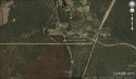
If you take a line directly east from 309 The Boulevard, it ends up on the West side on Mundaring Weir Rd just north of the Powerline track. A fairly accurate measurement gave me 31°55'38.91"S, 116°10'52.00"E I have been to this spot for a quick look and its not very dense, pretty easy to search there.
If you take a line from 309 The Boulevard (halfway) and then travel at a right angle to the existing line towards the hills for the same distance, it ends up in Anketell Rd Mount Helena which is all private property.
If you take a line directly east from 309 The Boulevard, it ends up on the West side on Mundaring Weir Rd just north of the Powerline track. A fairly accurate measurement gave me 31°55'38.91"S, 116°10'52.00"E I have been to this spot for a quick look and its not very dense, pretty easy to search there.
It's still a link and a fact.
Not saying the CSK is the same person to do with Mott but could have a connection in some way.
With the little info the police have given out over the 20 years anything "new" that comes to light should be worth looking into a bit.
Why aren't the Police telling the public everything they know about Lisa Mott? It's been 36 years. What are they waiting for? A confession?
Why would SS be DIRECTLY east? The CG JR line is not exactly north south, its about 12.5 degrees from North/South.
If you take a line from 309 The Boulevard (halfway) and then travel at a right angle to the existing line towards the hills for the same distance, it ends up in Anketell Rd Mount Helena which is all private property.
If you take a line directly east from 309 The Boulevard, it ends up on the West side on Mundaring Weir Rd just north of the Powerline track. A fairly accurate measurement gave me 31°55'38.91"S, 116°10'52.00"E I have been to this spot for a quick look and its not very dense, pretty easy to search there.
I don't think SS would be on private property.
So early 20's around SS
One of the main reasons the CSK hasn't been found is due to family and friends dismissing them without consideration
This could be another clue. Perhaps his family do not reside in Perth?
Why would SS be DIRECTLY east? The CG JR line is not exactly north south, its about 12.5 degrees from North/South.
If you take a line from 309 The Boulevard (halfway) and then travel at a right angle to the existing line towards the hills for the same distance, it ends up in Anketell Rd Mount Helena which is all private property.
If you take a line directly east from 309 The Boulevard, it ends up on the West side on Mundaring Weir Rd just north of the Powerline track. A fairly accurate measurement gave me 31°55'38.91"S, 116°10'52.00"E I have been to this spot for a quick look and its not very dense, pretty easy to search there.
Nearest crossroad please?
WolfDen
Active Member
- Joined
- Nov 28, 2016
- Messages
- 63
- Reaction score
- 150
Attachments
Why would SS be DIRECTLY east? The CG JR line is not exactly north south, its about 12.5 degrees from North/South.
If you take a line from 309 The Boulevard (halfway) and then travel at a right angle to the existing line towards the hills for the same distance, it ends up in Anketell Rd Mount Helena which is all private property.
If you take a line directly east from 309 The Boulevard, it ends up on the West side on Mundaring Weir Rd just north of the Powerline track. A fairly accurate measurement gave me 31°55'38.91"S, 116°10'52.00"E I have been to this spot for a quick look and its not very dense, pretty easy to search there.
Agree, can't see the direct east logic either.
Let's say LM was the CSK, wouldn't her body be on the line too?
What is the halfway point between Collie and GC.
Or the halfway between Collie and Claremont?
What is the distance between GC and JR? What is this distance south of JR?
Sent from my iPhone using Tapatalk
Mundering Weir Road and McCallum Road
Thank you for the map. That's great!
WolfDen
Active Member
- Joined
- Nov 28, 2016
- Messages
- 63
- Reaction score
- 150
Who uses the Mundaring Loop Trail?
I haven't. But I do go camping/4WD a lot. And this location reminds me a lot of Pipidinny Road a lot. Even has 4WD access like it...
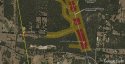
I spent about an hour out at this location the other day, and IF this is a potential dump site, this map shows the most likely areas to search for a body in my opinion.
RED = Most likely dump site area (most private, away from homes)
ORANGE = Slightly less likely but still possible.
GREEN = Unlikely (due to being too far from track, too close to main road, or being too close to homes therefore lack of privacy)
Areas not colour coded are either private property, not close enough to the line, too public or too difficult to access without a 4x4.
CSK has selected quite private locations for dump sites so far.
Attachments
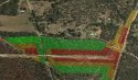
I spent about an hour out at this location the other day, and IF this is a potential dump site, this map shows the most likely areas to search for a body in my opinion.
RED = Most likely dump site area (most private, away from homes)
ORANGE = Slightly less likely but still possible.
GREEN = Unlikely (due to being too far from track, too close to main road, or being too close to homes therefore lack of privacy)
Areas not colour coded are either private property, not close enough to the line, too public or too difficult to access without a 4x4.
CSK has selected quite private locations for dump sites so far.
In this general area back in the 90's would the houses be fulltime occupied or were a lot of "hobby farm" properties for the weekends?
I'm just going to post a few of the locations that in my opinion may be some of the most likely dump sites. All of them are places of interest do do with shapes/lines. Will explain as I post them.
Somewhere I read that the killer may be a 33 degree mason. Longshot but hey. This is the exact point near bakers hill that forms an equilateral triangle. Its on private land and I have no idea it its accessible to the public.

RED = Most likely dump site area (most private, away from homes)
ORANGE = Slightly less likely but still possible.
GREEN = Unlikely (due to being too far from track, too close to main road, or being too close to homes therefore lack of privacy)
1. Bakers Hill area


2. Bunning Rd Bushland Mt Helena

Somewhere I read that the killer may be a 33 degree mason. Longshot but hey. This is the exact point near bakers hill that forms an equilateral triangle. Its on private land and I have no idea it its accessible to the public.
RED = Most likely dump site area (most private, away from homes)
ORANGE = Slightly less likely but still possible.
GREEN = Unlikely (due to being too far from track, too close to main road, or being too close to homes therefore lack of privacy)
1. Bakers Hill area
2. Bunning Rd Bushland Mt Helena
Attachments
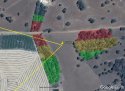
I'm just going to post a few of the locations that in my opinion may be some of the most likely dump sites. All of them are places of interest do do with shapes/lines. Will explain as I post them.
Somewhere I read that the killer may be a 33 degree mason. Longshot but hey. This is the exact point near bakers hill that forms an equilateral triangle. Its on private land and I have no idea it its accessible to the public.
RED = Most likely dump site area (most private, away from homes)
ORANGE = Slightly less likely but still possible.
GREEN = Unlikely (due to being too far from track, too close to main road, or being too close to homes therefore lack of privacy)
Nice thanks for this
Seems unlikely mainly due to the distance travelled.
Private property has potential for SS due to not being found as easy as the others.
The police have no reason to search your yard if your not a POI
Ok, I rarely believe in coincidences. But please tell me, what serial killer has ever dumped the bodies of their victims, where it has made up or caused a pattern? I had a look at old cases, but haven't been able to find or remember any. There has been theories in the past about other serial killers but none of those have ever been proven.
See if you can get a book titled "Tracking Down Serial Killers" by Dr Maurice Godwin.
He is a University Professor who is used by the FBI and other law enforcement agencies for profiling killers. But he also talks about patterns and special grounds. By analysing patterns, he can get a good idea where the killer may live OR what sort of victim the killer prefers. So looking at the North South line running through Bayview Tce at that particular spot, he is showing that he prefers victims from that area. Given that there have been three victims taken from there. He is confirming that to his pursuers.
He is also showing that all his victims are on that line. So, in effect, other victims may be found while looking on this line.
Does anyone know the exact locations for Kerry Turner and Karen Tate's locations?
Who is Lisa M. Or do you mean Sarah M?
Lisa Mott
Mentioned in the tigermoth video
- Status
- Not open for further replies.
DNASolves
Staff online
-
 WS AdminAdministrator
Online statistics
- Members online
- 147
- Guests online
- 2,649
- Total visitors
- 2,796
Totals may include hidden visitors.