Australia Australia - Prabhdeep Srawn, 25, Canadian, Snowy Mtns, NSW, 13 May 2013

DNA Solves
DNA Solves
DNA Solves
As we head into spring more people will be out hiking, so the chance he will be found is higher than in winter. Also, as the snow thaws there is a better chance of finding him.

:(
Cant believe how mild the winter has been!
Hopefully they'll be able to expand the area considerably too once the thaw starts.
 
An interesting article regarding people who have gone missing in the Australian Bush.

The Australian News. Read More...
Cunningham agrees. "There are just so many areas you can miss, and unfortunately bodies give no feedback. A lot of the time it's impossible to say, hand on heart, that you've searched every square inch, because you just can't." Searchers, though, still face failure-related anxieties. "We dread turning on the news and hearing that the person has been found in an area we've already searched. It's our worst nightmare."

The report goes on to speak about Prabhdeeps situation and what has happened in relation to his search.
Below are some extracts from the long article:

- See more at: How does a bushwalker go missing, never to be found?
RICKY FRENCH THE AUSTRALIAN AUGUST 31, 2013 12:00AM

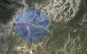
In June this year NSW police called off their search after weeks of scouring the freezing, bleak Snowy Mountains for 25-year-old Prabhdeep Srawn, who'd gone missing on May 13. Srawn, a Canadian who was studying at Bond University on the Gold Coast, left his rental car in Charlotte Pass Village and set off to hike to Mount Kosciuszko. Whether he made it or not we may never know. Srawn was only noticed missing a week later, when his car wasn't returned. On hearing the news from police his family immediately flew out from Canada. -
-----

Srawn's family refused to believe he was dead. His military survival training - he was a Canadian Army reservist - would keep him alive, they claimed. He would eat caterpillars, ants, anything it took. The word "impossible", they said, was not in his vocabulary. They lashed out at the decision by the NSW Police to call off the search and launched a social media campaign to get it resumed. Emails were sent to the Australian High Commission requesting intervention. More emails ricocheted around government departments, here and in Canada, going all the way to the office of the Canadian Prime Minister. Srawn's sister, Mandeep, and other family members wrote impassioned pleas to various authorities, going over the search in minute detail, accusing NSW Police of incompetence at best, heartless apathy at worst. -
-----

Snow hides everything. It's a blanket that brings cold, hypothermia and death; a blanket that can't be tossed off. It's nature's temporary eraser, wiping out all evidence until the time is right to reveal a landscape's true form. It washes away footprints as thoroughly as any ocean wave on the sand, and paints everything it touches in a harsh, disorienting, deathly white. In summer, the Kosciuszko area is full of defined landmarks, deep valleys and peaks, vegetation, rocks, well-worn tracks, roads and boardwalks to guide a weary hiker home. In winter, it may as well be a different planet. -
-----

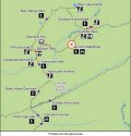
Klaus Hueneke, renowned for his books and photographs of the Australian Alps, led a successful search in 1988 to rediscover the site where Hayes' body had been found. I ask him about the Srawn case. He explains: "Finding a cairn or a body in that landscape is like finding a contact lens on the bottom of a swimming pool. Between Mount Townsend [where Srawn's last mobile transmission came from] and the Alpine Way is one of the most rugged valleys in Australia. It's cold, wet, treacherously steep, full of fallen trees, difficult rivers to cross, almost as tough as temperate rainforest in Tasmania. His body may never be found, irrespective of the size of the reward. I don't think he wanted to vanish, but if he did it was a good place to do it."
-----


Praying for Prabhdeeps family and friends - and for Prabhdeep.
Hope remains of finding him.
 
Are there any images posted anywhere that show the search area etc??? I remember it took until the snow melted until they found those guys who were behind perisher - they had made a snow cave and suffocated when snow fell and blocked the vents...

It just goes to show how close they can be and not be found - While I wait for the Gary Tweedle story to pan out further, I'm going to spend some time concentrating on this one now...
 
Im not aware of any area maps of the searches - though there was a concentrated area to the west of Mt Townsend, and Police had done a search to the North in the initial stages of the search, and around the Pass.

Just dding this bit of information - don't remember seeing it before...
Not confirmed, but I wonder if Prabh had also taken this jacket along with him.

NSW Police today issued a statement describing Mr Srawn as being of Indian appearance with a tanned complexion, medium build and short dark hair.
He was last seen wearing a white t-shirt and blue jeans. Police also believe he may be wearing a red and black "Frogg Toggs" ski jacket. The body of the jacket is described as being red with a black hood and shoulder section.

SMH Read more:

Picture: SMH: The rugged area west of Mt Kosciuszko where the search for Prabhdeep Srawn is now centred. Picture: James Morrow, taken with permission from his excellent ozbc.net website

Shows well the environment that they were trying to tackle when the snow began in Winter. Not long now until it will be gone and a new search can begin.

428451-snowies.jpg


.
 
OK - sitting down with this one tonight, going to try and catch up with as much of it as possible and get hold of some proper contour maps etc. I've attached a little "highlight" that circles the areas my initial thoughts on where I would be searching if I were there... but that is based on NOTHING other than where major changes of direction would have been planned or occur on a known track, but may not have been followed due to a change in terrain appearance with heavy snow.

Having completely missed a once plain in sight 90deg left turn and instead plowed into a fence in a car after just a light dusting of snow in Austria, I know how easy that would be.


Probably a bit premature for me to put something like this up yet - I haven't read through the entire thread yet and still have to learn the facts - FigTree can you summarize if possible what the facts are here - you seem to have been on the case ;)
 
This is taken from Google Earth - The first from user Treix, shows Club Lake - which is approximately where the snow/rain appears to have been coming down on the above "mud map" - and shows the terrain that is typical of that area...


I wonder if he (having some survival training) has attempted to follow the creek from the lake down after becoming lost, and is therefore somewhere on that line?

The next two are Photo's credit Jake Mohr - These are photo's that are also typical of terrain in the area... I believe they actually show the same area captured in the SMH photo posted previously by FigTree without snow..


I'm thinking out aloud here, so everything I am posting here is just ideas and may change post by post until I get a better grasp on everything here - still gathering a full picture of what the facts and known locations are here....
 
Another article today in the Sun Herald on Prabhdeeds search...
Missing Canadian tourist Prabhdeep Srawn's family still hopeful despite search being called off


(attach 1) The article in the Herald Sun also shows a map of the route he was planning to take.

(attach 2) MAP 1: When I mapped out his planned route there was an inconsistency with the Google map - Mt Townsend was to the left significantly further and off the track.

(attach 3) MAP 2: Yet when I put in the 'walking route' map the Mt Townsend marker(D) had moved right and followed the trail to Mt Kosciuszko on the ridge.

It maybe nothing, but I wonder if maybe the maps he was using showed a different route or one that is not very well laid out. His voice was heard North of Carruthers Peak <--- Is that fact??? (c), but in the mountains voices travel - I wonder if he was to the left of Carruthers Peak where the map (2) shows Mt Townsend(D) is?

(attach 4) Looking closer at the walking track I can see how the track seems very *zigzaged - it would be easy to be disoriented in the snow of where the track actually is - and which track was which. The map shows the trail without snow, but the weather has turned.

Mount Kosciuszko - Wikipedia, the free encyclopediais the highest Mountain in Australia.

Hopefully he will be found very soon.
Prayers for him and his family.

Excellent post - Google Earth does nothing to show what that terrain is really like though does it... *starts digging for those contour maps* Its a pitty its 8hrs drive from where I am! :(
 
OK... based on the claim that his voice was heard north of Curruthers Peak, I'm going with my theory that he missed a 90deg turn as the walking track was covered by heavy snow and rain as he was trying to backtrack towards his ingress path - so expanding on one of my initial circled "areas of interest for search" previously posted, this one is where I would be focusing.

This is based on:

a) his voice being heard north of Carruthers Peak (which this area is)
b) the 90deg turn/return to base theory
c) heavy snow making that path of RTB difficult to follow and that turn being missed
d) following a valley down to safety (which is basic survival 101)

Here is my revised "mud map"


...and here is a Google Earth of the area.

 
Most of that area in the "red box area of interest for search" above is thick scrub... would be very difficult to move through...

*If* I were to try and put myself in his mindset in that situation - if he indeed did overshoot the right turn off the path near Carruthers Peak and enter the "area of interest" highlighted by MaYHeM above, then possibly he has been caught out by the weather with the heavy snow/rain hitting him while he was right up on that ridge along Carruthers Peak/Club Lake section.

Maybe he has pressed on for a while and possibly, he might have even been past the half way point of this (weather affected) area... he may have even been able to see the snow line ahead and below him on the established walking track (still heading toward his intended goal of Kosciuszko)... tempting him to continue on... but I believe that common sense would have told him to turn around and backtrack a return to the start point/his car at this stage, realizing that even if he presses on toward Kosciuszko now (well aware that its even higher than his current location). It doesn't take the local news weather man to realize that Mt Kosciuszko and the remaining high altitude terrain ahead would likely be subject to similar if not worse wind/snow/rain conditions than he was currently trying to escape... so he has made the right choice and scrubbed the mission.

So with that decision made, he's turned around and begun backtracking at this point, walking back into the thick of it.

SIDE NOTE: I'm doubtful that Hypothermia was an issue at this stage though - he was excerciing heavily at this time and had multiple layers of clothing as well as what one would assume is some pretty good experience with cold/snowy conditions and outdoors/hiking given his Canadian background and obvious interest in outdoors and hiking activities.

So he's turned back ... but in just a few hundred meters or so, he's come to that 90 degree right turn as it appears on the trail maps and mud maps posted here already - and now, the snow has changed the landscape.
The once fairly obvious track/trail has dissapeared under a layer of freshly fallen (and falling) snow, with white out visibility down to a few meters.... and being the only person up there, there were no recent tracks in that snow from anyone else to indicate the change of direction.

This has seen him overshoot the turn and instead he has continued north, and eventually that has brought him downhill into the valley immediately ahead as in the above pics and google earth screen shots. There's no telling at what point he actually realized he was off track, but even if/when he did, he may have chosen to get below the snowline and weather as priority over retracing his steps back up into the blizzard at that point.

As he's hit the creek in the trough of the first valley just north of there, he's realized he's way off track, and made the decision to follow the creek down the valley (which is another sensible thing to do) and that's where it has come unstuck for him.

If this is indeed the case - his decisions and choices made up until this point were pretty good. Apart from not telling someone where he was going etc (Basic Rules of the Bush/Hiking) - he has assessed the weather as a greater threat and his mistake in missing the snow covered trail course change is a mistake anyone could make. He's chosen to head down the valley and creek for safety - but IMO, if indeed this is where he went (which supports the claim his voice was heard in that area), he has realized how dense the scrub was anywhere other than smack bang in the middle of the creek bed and its rocks - and has come to grief on one of the many smooth/large/round/awkward granite boulders that make up the creek line - injuring himself to a point of being completely debilitated and unable to move anywhere.

It was only a matter of time in the dropping temperatures, rain and shortly, snow - before hypothermia set in and he has died. A few days at most.

If he had a compound fracture that was stopping him advancing further, then that also means infection is another factor that would mean long term survival was going to be unlikely here.

SO, I don't think anyone is under any illusions that this will be a truely happy ending, but hopefully the family will get some closure if they can bring him home...


Hopefully though this post provides some insight into a potential mindset or thought process he may have followed... and IMO it's in keeping with decisions that someone who had some hiking/outdoors experience and some basic survival knowledge, might make. If one is to lend any weight to his military background or basic survival training that has been spoken of, then the above scenario shows someone that for the most part, made rational and logical decisions, but encountered problems worse than the weather that day...

The above is of course completely speculation and guesswork... and... JUST A HUNCH....
 
Welcome to Ws Derryn Hunch and thanks so much for your amazing informative post and to
MayHem for the spectacular pics!
 
What dotr said!! Ditto!
Great first post Derryn Hunch!
Welcome to the thread and thanks for your input!

:wagon:

Thanks for the maps and pics too MaYHeM - I was forgetting my manners.


In the attachment below is the 2km radius out from Mt Townsend (West)
SourceThe first big clue that they received was the phone records ping from Prabhdeeps cell phone which was from the West Face of Mount Townsend. The range is 2km on the map the arrow to the West. The track to Mount Kosciusko is in red - and the track that leads directly back to the car park in is orange.
This is the 'walking map' if you go onto google and it is set to 'car' then Mt Townsend is not in the same place - it is to the left further.


The search (2 months after the Official Search was called off) also re-examined Carruthers Peak, the Huts near the Geehi River and down to the Alpine Highway.
There have been extensive searches up until the time the weather and snow set in to make things impossible to see and search.
Two weeks before the Snow started to really fall hard, they had Australian Search and rescue dogs looking for Prabhdeep - they also had dogs come in from New Zealand.

I will try and get a timeline together tomorrow.
 

Attachments

  • 2 km radius west of Mt Townsend with track marked.jpg
    2 km radius west of Mt Townsend with track marked.jpg
    125.5 KB · Views: 17
I had read that the search area had concentrated on that area around Kosciuszko - wasn't aware that the reason for that was based on phone tower/locale records... trying to understand exactly what your post means in regards to that though FigTree... just to clarify (yes your post is very clear just need this spelled out to me haha!) -

(Correct me here if misunderstood!):

* His phone pinged a tower on the west face of Mt Townsend?
* The range of the phone is limited to 2km, so that implies that he was within that range/radius of this tower?

My questions:

Was it a non-directional signal and just range contact with this particular tower (which could have come from any direction within a 2km radius) or did it provide a basic directional record?
If so, Was it solid WEST FACE or NORTH WEST FACE or SOUTH WEST FACE?

Was there any record of sms/calls?

What times were these signals/sms/calls (if any) logged?

What are the range limitations and areas of coverage/dead spots of the Mt Townsend tower?

I'm still siding with the North West area discussed above - it still fits with the west face signal ping (pending clarification of the above questions of course) and the West face of Mt Townsend is in fact North West facing, and the way I see it, should have no issues picking up a signal from a phone in the area outlined by MaYHeM...
 
I had read that the search area had concentrated on that area around Kosciuszko - wasn't aware that the reason for that was based on phone tower/locale records... trying to understand exactly what your post means in regards to that though FigTree... just to clarify (yes your post is very clear just need this spelled out to me haha!) -

(Correct me here if misunderstood!):

* His phone pinged a tower on the west face of Mt Townsend?
* The range of the phone is limited to 2km, so that implies that he was within that range/radius of this tower?

The information came from the ABC News on the Tuesday 11th June -
As far as I know the Phone Ping indicates the phone was within the Western side of the radius area - though they did not give specific co-ordinates. I put a Google compass over Mt Townsend for the direction. The concern is the exact location of Mt Townsend from Google Maps. It would be slightly more left of the spot it is marked (if anything).

He says Mr Srawn's mobile-service provider has found the last signal was sent from the west face of Mount Townsend.
The location has a 2 kilometre radius of accuracy.

From the report it didn't clarify the exact search locations West of Mt Townsend - but it does say that they have also checked west of Mt Kosciuszko. They have covered a large amount of ground (stated in msm) but as in the exact locations, I'm not sure.

Up to 30 searchers from six state and federal agencies, plus two aircraft, are today continuing their search in a rugged area of peaks and ridges to the west of Mt Kosciuszko.

The fact they are searching there suggests that Mr Srawn may have summited Kosciuszko, then sought shelter beyond it after the worst of the weather arrived.

News.com Read More...
 
News today that the Reward offered by the Family has been withdrawn ...
From Prabhdeeps Facebook Page... Read More

Source: Canberra Times 24th Sept 2013. Read More...
The family of missing bushwalker Prabh Srawn has withdrawn the reward for finding the Canadian student, dead or alive.
His disappearance in May sparked months of extensive searches throughout the Kosciuszko National Park, attracting volunteers from across the world to the search for the 25-year-old.


LI-art-wd-missing-man-20130529203822457134-620x349.jpg

Sister of missing student Prabhdeep Srawn, Mandeep, at Lake Jindabyne. Photo: Rohan Thomson

.
 
Conflicting reports... some say he never made his destination of Mt Koscious... damn I am getting sick of spelling that... Its "Mt K" from now on... ;) - and other reports/search plans were based around "he did"...

I suspect that the MSM report that states that he and his phone were pinged as being "On the West Face" of Townsend is poorly worded and the signal was pinged by a tower on the West Face, meaning the above discussion by Myself, MaYHeM and FigTree is on point still when we infer that the radius of signal communication applies...

Correct me though if that's way off the evidence base though - I haven't actually looked at any more than the last few pages of this thread re: this case... (Shame! Shame! Shame!)
 
Interesting the timing on the revocation of the reward offering - I guess the family figure they've waited out the winter now and its likely that the increasing number of spring/summer hikers in the area will draw a result for them now soon...

I gather the family were less than impressed with the efforts and organisation of the initial primary search for Prabhdeep too - which I can sympathize with to some degree... but I don't think they really understood the remoteness of the area and terrain that (on top of the deteriorating weather) was not exactly encouraging...

I think the Reward was a very good way to keep the interest about Prabhdeep's disappearance active, and there were many stories of people involved who weren't on the search because of the Reward (which is so heartening).
I also think that a resource of that amount could make a difference with the type of search they are conducting next. The funds can go into searching for Prabhdeep. Maybe that allows them another helicopter search or a specialized search team or piece of equipment.

I will put the timeline thread up tomorrow - its almost ready to go - but looking at the circumstances and the timelines, I think they had reasonable concerns at the time - it had already been a week after Prabh's disappearance before the search started, and then that was hindered to begin with by weather.
 
* His phone pinged a tower on the west face of Mt Townsend?
* The range of the phone is limited to 2km, so that implies that he was within that range/radius of this tower?

What are the range limitations and areas of coverage/dead spots of the Mt Townsend tower?
.

One thing I am not sure of is where the Tower is in the area of Charlottes Pass.

Though I did find some information that the Telcos give of their coverage of their networks, but once again it depends on the device, if you are using data or voice call, if you are 2G, 3G, 3G dual, 3G outdoor antena, 4G ...

But on a basic search of Telstra and Optus - West of Mount Townsend there is a big gap in coverage, especially below 1800mtrs, and in the valleys - and the Telstra map says 'no coverage' without an external antenna.
I have put 2 Maps in the attachments - both assuming a basic 3G coverage -

The point I chose is Charlotte's Pass - as the maps rely on street addresses.

This website is a good tool - it shows the coverage of many different network area in Australia - by carrier.
Telco Antennas

Though considering the time that had passed before Prahb was known to be missing (1 week), I would assume his battery would have been flat after a few days.

Pic 1) Telstra
Pic 2) Optus
 

Attachments

  • PHONE COVERAGE MAPS MT K.jpg
    PHONE COVERAGE MAPS MT K.jpg
    62.2 KB · Views: 3
  • PHONE COVERAGE MAPS OPTUS MT K.jpg
    PHONE COVERAGE MAPS OPTUS MT K.jpg
    60.7 KB · Views: 4
Information on the Main Range Track to Mt K. Loop back to Charlottes Pass - and beyond to Alpine Way.
Interestingly this nswgov site gives the walk time as 9 hrs.
So far I have seen anywhere between 3 - 12 hours to complete this walk.
It is dependent on the weather.


Main Range track
Distance
22km (loop)
Time suggested
9 hours
Difficulty
hard

Main Range walk is a spectacular, long alpine track, which is suited to adventurous bushwalkers eager to explore some of the most beautiful parts of Kosciuszko National Park on foot.

You can follow this 22km track through some truly extraordinary scenery; across the Snowy River, through fields filled with wildflowers, past two gorgeous scenic lookouts, then high up along the scenic Main Range climbing Mount Kosciuszko, before returning via Summit trail to Charlotte Pass.
Spring and summer are particularly great times to visit, when the snow has melted off the track and the wildflowers are out in full bloom.

Plant communities: grasslands, alpine plant communities, freshwater wetlands, heathlands
 

Attachments

  • MAIN TRACK WALKING MAP.jpg
    MAIN TRACK WALKING MAP.jpg
    56.1 KB · Views: 8

Staff online

Members online

Online statistics

Members online
56
Guests online
3,074
Total visitors
3,130

Forum statistics

Threads
604,274
Messages
18,169,959
Members
232,271
Latest member
JayneDrop
Back
Top