


HinterlandObserver
Well-Known Member
- Joined
- May 5, 2020
- Messages
- 528
- Reaction score
- 3,122
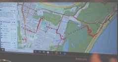
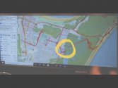
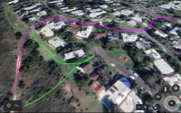
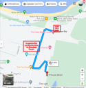
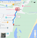
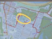
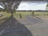
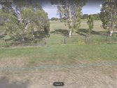
I would love to hear your thoughts on the other disregarded markers on the route, see pics attached. The dot on Massenger st (which I think correlates with the google cell ping), the one on the corner of Carlyle and Cowper that looks like its entering the property there, and the one at the top of the Milne track. This has always intrigued me, it looks as if he cuts through a house yard, into Evans st (theres a childrens park there and several of the blocks on that road backing onto the national park have since been knocked down and rebuilt but google earth still has streetview of 2019 so you can see he could have run through there at the time) and back out onto the Milne track?@ 00:55. There's a 17-minute pause of phone activity between the time Theo uses his camera at 00:38 and a WhatsApp message he sends at 00:55. Interestingly, according to Google maps (see image ) it is exactly a 17-minute walk from the tip of the lighthouse road (where he might have taken a picture of the lighthouse?) to the Captain Cook Parking area which is very close to Theo's last CEL location data @ 00:56. (this location data could be unreliable? Then again, maybe not?)
View attachment 375717
View attachment 375719
View attachment 375720


") they'd be available at the hostel. I don't know enough about the texts he sent but not sure you could always tell if someone was wasted. He could have just been impaired enough to make some poor decisions, but still good to write text messages and watch TV.
they'd be available at the hostel. I don't know enough about the texts he sent but not sure you could always tell if someone was wasted. He could have just been impaired enough to make some poor decisions, but still good to write text messages and watch TV.