espirtu pampa
Well-Known Member
- Joined
- Jul 21, 2019
- Messages
- 183
- Reaction score
- 765
Thank you very much, mussopossum, for all your efforts. Now your account is very clear to me.


The parents of Belgian backpacker Theo Hayez reveal the 'grey areas' in police investigation | Daily Mail Online
The missing pieces in the hunt for Theo Hayez: Belgian backpacker's dad breaks his silence after search was called off to reveal the 'grey areas' in police investigation
4. final ping as per msm map
If you zoom in to this other photo you will see area where fence is. This is where it seems other red dots were where he walked up did a loop on map then back again I may also note the area where fence was there was fair bit rubbish like cans butts etc in one spot but could be due high tide
@mussopossum , thanks again for all the photos!
Initially I was thinking why didn't I go over to the rocks and take a look, when I was there (a week after you?) Only now it dawns on me, it was close to high tide when I went! What I saw was very different from your view. I only saw the tip of the highest rocks in your photos, I think. That area just looked like part of the sea.
The other thing is, what is Google Map's assumption for drawing coastlines - high tide or low tide? Not a question in geography classes in my day for sure. I went to the beach and assumed I found the "last spot" on Theo's route. That was based on the coastline I saw at the time. It must be metres up from where you were located at,
Do you see what I mean? It's getting late, no time to look up photos... Later...


Just to add that I was there on 9 Aug... Will look up tides later!This was what I was saying in my last post. If you compare the photos I posted, which were taken at high tide on 27th July to your photos at low tide on 2nd August you can get an idea of the difference.
The high tide on 27th July was 1.46 metres at 4.41pm
High tide on 1st June was 1.41 metres, low tide .04 metres.
Low tide on 2nd August was .011 metres at 2pm.
View attachment 205250 View attachment 205250 View attachment 205252
It's interesting to note that the different tide heights in the days after Theo was last seen as well.
As I said with the pics on page 4 @Via Marple ; the rock area water level and level from down the beach look very different.
Hope this gives a bit of insight into the tides and photos.
I had this photo in my screen shots too...don't remember why? But it may give an idea on the tide and shoreline?
View attachment 205254
Good idea to head back and check out different tide heights and the rock area in particular!
Edited to add For some reason your quote wasn't added to this reply @mussopossum . Was meant too..
Just to add that I was there on 9 Aug... Will look up tides later!
Too bad I am now holed up in the big city, no chance returning any time soon.
Also we may be looking like nuts to some.... A route that is unconfirmed, family said it is not 100% accurate. And yet we cling on to it.
But don't forget, the search group seems sure about it. They are not saying of course. But you get the hints.
")
I wish LE would publish (if any) route.
There is also that Map from when the Belgians were here too to consider however that appeared to only be their walking map
I am happy to look like a nut
I enjoy beach walks and it is a day out for me.
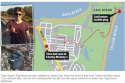
That's interesting given that the first area of search after the ping was made public was in the bushland at Clarke's Beach. I'm wondering if the Cape tower only might serve that.The one thing I just noticed looking back at my photos is that the ping kept changing between Tallow Beach and Cape Byron Conservation. Interesting.
Clarkes is where the Cafe and the camping ground is on the beach. From main beach it runs past Clarkes to The Pass at the end. Road down into The Pass. Bushland in and around The Pass. I think the search was from Clarkes so it took in that bushland heading towards Wategoes and possibly ocean side of the road."That's interesting given that the first area of search after the ping was made public was in the bushland at Clarke's Beach. I'm wondering if the Cape tower only might serve that."
Where is Clarke's Beach ? I can't find it on Google Maps.

The problem with investigating a potential serial killer is it takes time and a lot of investigation. More victims will, unfortunately, present a pattern and people will have information. Time and personality reveal the unsub IF they are revealed at all. Some psychopaths desire recognition and will get in touch with the police. This is how BTK got caught. They also insert themselves into investigations (a lot of them). Time. Investigation and following all leads.How do police investigate this type of thing, if these lads are all found much later in the water, or not found at all?
It's like Ivan Milat. No-one can know unless someone survives to tell their story.
Top forensic psychologist Tim Watson-Munro says believes Theo could have been the victim of an unknown serial killer, along with two 20-year-old backpackers who went missing on the NSW north coast months prior.
The parents of Belgian backpacker Theo Hayez reveal the 'grey areas' in police investigation | Daily Mail Online
What's actually interesting about the Ivan Milat case, is there were police errors made along the way. The police could have caught Ivan sooner. Paul Onions, when he escaped from Ivan, went to a police station, but it was closed. The second police station he went to was so far away, that it was too late to catch Ivan. Paul Onions also made several phone calls to the Aus police, was it wasn't taken seriously till years later. I'm a bit foggy on the details, as I researched this case years ago. I think I have mentioned this before, but a forensic psychologist and Milat's first lawyer believe there was a second Unsub. I'm not sure that Task Force Air got it completely right.The problem with investigating a potential serial killer is it takes time and a lot of investigation. More victims will, unfortunately, present a pattern and people will have information. Time and personality reveal the unsub IF they are revealed at all. Some psychopaths desire recognition and will get in touch with the police. This is how BTK got caught. They also insert themselves into investigations (a lot of them). Time. Investigation and following all leads.