papertrail
Former Member
- Joined
- Oct 17, 2015
- Messages
- 2,573
- Reaction score
- 2,618
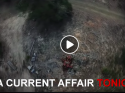
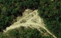
This is very close to William's (it's just off his road & joins the track leading to the cemetery). I didn't see any old vehicles in this spot in sept 17. It seems a larger area which they are viewing on ACA from the drone IMO. Plus if you look at the car, there's a few other rusty things off to the side. Wouldn't fit here in terms of space. Here's a still of the ACA piece with other rusty stuff - to the left of screen
They are logs of wood and debris of wood I believe. Looking on a large screen.
This is all a beat up by ACA. Their credibility level will take a nose dive into the abyss.
BTW the measurement calculated using SixMaps, of the area that show bare earth (not the forrested area) is 28 metres north south, east west 48 metres so that is quite a large area. It appears to match the area shown from drone. If you watch carefully as the footage spans out, you will see the dirt track angles the same as it does in the screen shot.
Last edited: