
Install the app
How to install the app on iOS
Follow along with the video below to see how to install our site as a web app on your home screen.
Note: This feature may not be available in some browsers.
You are using an out of date browser. It may not display this or other websites correctly.
You should upgrade or use an alternative browser.
You should upgrade or use an alternative browser.
Recovered/Located CA - Cecil Knutson (dec'd), Dianna Bedwell (inj'd), Valley Ctr, 10 May 2015
- Thread starter TravelingBug
- Start date


New Posts
-
Missing woman’s body found ‘mutilated,’ wrapped in sheets at cemetery, officials say
- Latest: imstilla.grandma
I live in this area. The roads around here are country type. Aka; Winding and curvey.
It would be very easy to mis-judge and end up over a cliff or in a deep gully.
Thnak you, KALI, glad you're here. What would it have been like, traffic considerations around that area on Mother's Day?
GigTu
ѧѦ ѧ︵ ̧̱ι̵̱̊ι̶̨̱ ̶̱ ︵Ѧѧ︵ ̵̗̊o̵̖ ︵ѧѦ Ѧ ѧ
- Joined
- Aug 6, 2013
- Messages
- 9,365
- Reaction score
- 1,605
Forager and FindHG.... :loveyou:
You our are both amazing. Thank you for jumping in and providing your map expertise. Looking at the updated version of your map (thank you for satellite view), I wonder if in fact it would be about 15 minutes by the time they reached the dead zone. It seems it would actually be 9-10... But what if dad was struggling so they switched seats and mom was at the wheel? That would explain her phone being turned off, the unexpected direction towards perhaps a hospital, and a nervous driver behind the wheel. Dad's phone no longer providing a signal makes sense to the dead zone, and if they did end up on the roof it explains no gps signal from the car.


You our are both amazing. Thank you for jumping in and providing your map expertise. Looking at the updated version of your map (thank you for satellite view), I wonder if in fact it would be about 15 minutes by the time they reached the dead zone. It seems it would actually be 9-10... But what if dad was struggling so they switched seats and mom was at the wheel? That would explain her phone being turned off, the unexpected direction towards perhaps a hospital, and a nervous driver behind the wheel. Dad's phone no longer providing a signal makes sense to the dead zone, and if they did end up on the roof it explains no gps signal from the car.
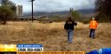
Team Amber Rescue to help search for missing couple
CBS 8 from this morning's broadcast,
CBS 8 from this morning's broadcast,
Attachments
rosesfromangels
Amateur opinion and speculation only
- Joined
- Feb 24, 2010
- Messages
- 12,378
- Reaction score
- 63,480
Forager - to be precise, here is my sweetspot of a guess:

rosesfromangels
Amateur opinion and speculation only
- Joined
- Feb 24, 2010
- Messages
- 12,378
- Reaction score
- 63,480
Roses, do you think they could have driven that far in 15 minutes?
If they were in a hurry to get to a medical facility....maybe. Not sure.
Forager
Member
- Joined
- Apr 8, 2015
- Messages
- 851
- Reaction score
- 8
That's putting your money down! I've plotted the area, shortened it by a little a bit on the southern end to keep it out of a residential area.
Thanks for the pic. I've got a bit of a crick in my neck, but it was very clear and easy to transfer.
I read the back and forth with GigTu. The route from the casino to the beginning of your area is only about 15 miles, within that 15 minute window, I think, given those roads.
GigTu
ѧѦ ѧ︵ ̧̱ι̵̱̊ι̶̨̱ ̶̱ ︵Ѧѧ︵ ̵̗̊o̵̖ ︵ѧѦ Ѧ ѧ
- Joined
- Aug 6, 2013
- Messages
- 9,365
- Reaction score
- 1,605
Thank you. I guess I thought it was a different place, and would take longer from the casino to reach that part of the highway regardless of route. Going to check your updated map now (and put it in my sig line so I can find it easier) to see if I'm looking at the wrong place.That's putting your money down! I've plotted the area, shortened it by a little a bit on the southern end to keep it out of a residential area.
Thanks for the pic. I've got a bit of a crick in my neck, but it was very clear and easy to transfer.
I read the back and forth with GigTu. The route from the casino to the beginning of your area is only about 15 miles, within that 15 minute window, I think, given those roads.
")
Forager
Member
- Joined
- Apr 8, 2015
- Messages
- 851
- Reaction score
- 8
Forager and FindHG.... :loveyou:
You our are both amazing. Thank you for jumping in and providing your map expertise. Looking at the updated version of your map (thank you for satellite view), I wonder if in fact it would be about 15 minutes by the time they reached the dead zone. It seems it would actually be 9-10... But what if dad was struggling so they switched seats and mom was at the wheel? That would explain her phone being turned off, the unexpected direction towards perhaps a hospital, and a nervous driver behind the wheel. Dad's phone no longer providing a signal makes sense to the dead zone, and if they did end up on the roof it explains no gps signal from the car.
View attachment 74800 View attachment 74801
GigTu,
I had missed this earlier post of yours and wished I had responded earlier. The timing considerations hadn't dawned on me, and your post makes a lot of sense.
I can see how I confused things by putting those 'Deadzone areas' on the map without explanation. I've since added some more 'Cell deadzone' areas along likely routes. But Roses focus area was a separate thing.
Thanks for your post!
steelman
Former Member
- Joined
- Feb 26, 2014
- Messages
- 5,052
- Reaction score
- 258
Weather forecast for today:
http://classic.wunderground.com/cgi-bin/findweather/getForecast?query=valley+center,+california
Should be in the mid to upper 60's, little chance of rain.
Not bad conditions for searching, don't forget the mosquito spray.
http://classic.wunderground.com/cgi-bin/findweather/getForecast?query=valley+center,+california
Should be in the mid to upper 60's, little chance of rain.
Not bad conditions for searching, don't forget the mosquito spray.
JaimeSommers
Active Member
- Joined
- Jun 7, 2012
- Messages
- 2,408
- Reaction score
- 111
I wonder, is it possible to tell from the security cameras whether they sat in their car for a while before leaving, or did they drive off right away? Wondering if perhaps someone might have been hiding in the backseat when they got in.
Searching for Cecil, Knutson and Dianna Bedwell
Sand Crab News, May 16, '15
A yt :beats: video about the search and an interesting guess at a location.
Sand Crab News, May 16, '15
A yt :beats: video about the search and an interesting guess at a location.
FINDHG, thanks for sharing the video.
I'm super grateful to whomever made it, the text alone is a great compile, if paused to read. It took some effort.
steelman
Former Member
- Joined
- Feb 26, 2014
- Messages
- 5,052
- Reaction score
- 258
Who made the video ?
I don't understand the significance of places that were shown with closed gates and warning signs. Anybody want to explain it to me ? Where is all of that in relation to where they were last seen ?
I don't understand the significance of places that were shown with closed gates and warning signs. Anybody want to explain it to me ? Where is all of that in relation to where they were last seen ?
Forager
Member
- Joined
- Apr 8, 2015
- Messages
- 851
- Reaction score
- 8
Who made the video ?
I don't understand the significance of places that were shown with closed gates and warning signs. Anybody want to explain it to me ? Where is all of that in relation to where they were last seen ?
Sand Crab News offers a tantalizing trail of breadcrumbs for us there, but I haven't yet been able to connect the dots for myself. I have put a marker on the map to show the location of Turner Lake, a principal focus of the video, with a link to it. Turner Lake is off of Betsworth Rd, which runs west from Lilac Rd. in an area just to the west of the casino where the couple was last seen. (Scan down the list of map features on the left of the map screen and click on "Turner Lake (Youtube)")
https://www.google.com/maps/d/edit?mid=z_XRj_yu3Dto.khuzU1KdCXHY
Here's the link to the Sand Crab video on Youtube:
https://www.youtube.com/watch?v=Hq1j_RRYqGg
Kitty Alvarado reports, on May 13th, for KMIR News / NBC , 48 hrs after they'd been missing, and before LE released the video of the three white (by Lindsay Winkley, U-T San Diego, 5/13, 5:49 pm) cars at the light, that the Knutsons were, according to their daughter, regulars at he casino, at least on a monthly basis, with Players' cards, and guessing that they may only have had enough medication for the day with them in the car because they were planning to return home from the BBQ. Posted of review.
Treelights
New Member
- Joined
- Apr 17, 2013
- Messages
- 8,133
- Reaction score
- 115
Sand Crab News offers a tantalizing trail of breadcrumbs for us there, but I haven't yet been able to connect the dots for myself. I have put a marker on the map to show the location of Turner Lake, a principal focus of the video, with a link to it. Turner Lake is off of Betsworth Rd, which runs west from Lilac Rd. in an area just to the west of the casino where the couple was last seen. (Scan down the list of map features on the left of the map screen and click on "Turner Lake (Youtube)")
https://www.google.com/maps/d/edit?mid=z_XRj_yu3Dto.khuzU1KdCXHY
Here's the link to the Sand Crab video on Youtube:
https://www.youtube.com/watch?v=Hq1j_RRYqGg
What is a Sand Crab News? Do they work with LE?
The turkey vulture at the end is strange.
If the gates are locked, does this person think Cecil and Dianna have a key?
Frankly I don't understand the "tantalizing breadcrumbs", unless this person is working in conjunction
with Law Enforcement or saw Cecil and Dianna there, I don't understand this. Really.
IMOO.
DNASolves
Online statistics
- Members online
- 94
- Guests online
- 1,752
- Total visitors
- 1,846
Totals may include hidden visitors.