looking4OPH
Active Member
- Joined
- Oct 28, 2010
- Messages
- 321
- Reaction score
- 34
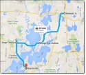
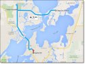
There was earlier talk about his potential route leading to the cement plant. With the footage in the recent WGN report that included the Citgo, I plotted the points that we know of. There are two Citgo stations in the area, but the receipt on the news report with Lt. Joe's signature confirms the Grass Lake Road location. (Is it odd that his signature was at the top of the receipt in an open area, not a signature line?) Other than the cement plant, I don't think any are confirmed for that morning, but are likely.
Antioch - Home is there, but is it known that is where he started from that morning?
Citgo - He bought cigarettes there according to the owner, but is it known that he stopped there that morning?
Snap Fitness - He worked out there, but is it known that he did that morning?
Cement Plant area - It is known that things ended there.