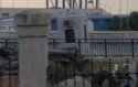
More precise dating of the Malaga photo. Looking at the left side of the photo.
the three flagpoles on the left provide a precise area for line of sight. Only three elements can be seen in that area. Nearest is a small, greyish, prefab hut – with one window. Next, a group of domed cylindrical storage towers. in the distance the trees and the hills.
Cylindrical domed storage towers.
For that area, the storage towers do not appear in the 26 nov 2005 satellite photo. They do appear in the 15 aug 2007 satellite photo.
The pivotal element is – the progression of the prefab hut.
The last satellite image with no hut (before hut appears) is 4 dec 2006. The headache with the hut is that in satellite photo 15 august 2007 it appears, but is not in the line of sight. It is off to one side. Sept 2008 the hut is now visible in streetview, has moved again, and is clearly discarded, not in use. it is leaning at an angle, in an area containing other disused junk. Same for oct 2009. May 2012 hut has gone.
The car park entrance has those orange metal barriers, making up a narrow entrance point. Nevertheless, driving through this car park would be a short cut to avoid the final official barrier to exit the port. Understandable why this little escape route would need to be monitored. I figure it would be the kind of hut to be positioned at that entrance point to the car park. when I placed it there, it fitted for size, and the rotation of the hut in the Malaga photo suddenly makes perfect sense. My conclusion - hut was placed there first, then at a later date moved off to the side. then at a later date abandoned. Then finally removed.
A more permanent concrete barrier running the whole way across this small car park entrance was put in place between 7 dec 2007 and 20 april 2009.
So I figure that the hut was in its Malaga photo position after 4 dec 2006 and before 15 august 2007
CB is in jail until 21 december 2006. Which leaves the window for the Malaga photo as 21 december 2006 – 15 august 2007. All imo.