Ruthbullock
Well-Known Member
- Joined
- Oct 27, 2016
- Messages
- 1,681
- Reaction score
- 8,153
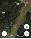
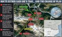
I am struggling to find the suggested full route that ED had taken to reach this ravine.The photo of the big ravine I shared earlier is within Chemin de l'Impératrice and is called 'Gouffre du Malaplatte', 'Gouffre' is a cave in french. It seems to be a stopping point on the trail, but if ED went off piste and accessed it from the wrong point obviously this could be a fatal mistake. Its unclear how long the ravine runs for or if there are any signs or barriers at the top.


There is a viewing point of a section of the cave along the trail
I have looked and looked through past posts and via google and AllTrails and don’t see how she hit the section being referred to. If anyone can post a link to the full walk (sorry if you have already done so and I just can’t find it)