After examining photos of the immediate area, and then taking a second (and then a third
")
) look at google maps that show where the creeks run and the terrain, it's becoming more and more apparent to me that the killer did indeed use an ATV of some sort to transport the body to this location. An ATV probably equipped with a mounted rear rack, used by hunters to transport game, which also explains the comment made by Mr. Bass of deer carcasses in the area. It's an area familiar to hunters.
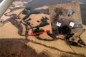
Assuming that ATVs do not have the capability to traverse creekbeds, I reckon the most likely avenue the perp used is via Chopin Drive, and into the ATV path that hugs the bank of the creek, as I have highlighted in the following map:
http://maps.google.com/maps/ms?hl=e...7.987893,-78.617263&spn=0.008388,0.01929&z=16
Why do I think this route is an ATV/hunter path? By examining Google earth, and the "Timeline" feature that allows you look at satellite imagery going back to the 1990s, there is a distinct "track" that runs from the Blandemar Farm Pond, hugging the line of trees and the creeks, down through where Morgan was found. Unfortunately, I don't know how to link Google Earth maps, but if you have google earth, you can examine the topography of the area going back to April of 1994.
The perpetuator is indeed a local. I think it highly unlikely they utilized their POV to get to this location. If I were law enforcement, I would be looking at that "access point" at Chopin Drive @ Blandemar Pond... taking a close look at locals who own all-terrain vehicles, or have easy access to one.