BBM- I've got tons of personal experience with raging torrents in this area. All of the local creeks, canal's , storm-water tunells and waterways are linked together through North Parramatta, Parramatta, Westmead and Wentworthville and even a trickling stream can become a deadly

during and after heavy rainfall
or steady rain in the surrounding areas. That's where the danger is.
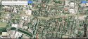
I didn't realise how misleading the overhead satelite view was until I mapped out the Nth Parra t/house where I used to live right next to a major canal/ storm tunnel.
Sydney water and the Parra council spent forever upgrading this catchment area (around 2004-2006-ish) which flows right into the parramatta river on the foreshore... but there were plenty of times when there was only a light drizzle where I lived but the canal was a seriously scary, raging
because it carried all the rainfall coming from the North. Any waterway running south carries the greatest risk.
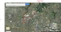
Even though the creek in question is so small that it doesn't show up on maps, it also runs south directly from Lake Parramatta and it looks like as though the Northmead reserves and creeks link up to that teeny tiny creekline too and it all gains momentum fast! (pic#3)
I think it was Xantara who posted about it 'bucketing down' on Tuesday night. The important question is where was it bucketing down? Westmead rainfall is collected at North Parramatta which is only about 1km away (or over 4km if you use driving routes with online mapping).
Tuesday is recorded as only 1.8mm rainfall, but Wednesday was a whopping 22.8mm, but I'm sort of half way between the two points and it might have been different in the heart of westmead.
I don't think there's anything odd about Amesha going out in the rain to get milk and butter. Residents who drive vs residents who walk or use public transport live in two very different worlds. We find and use shortcuts that motorists know nothing about, even if it takes us through some pretty seedy places. I've survived all these years without a licence and more people should be doing the same.
Coles is the closest, and it accept gift cards (mentioned by her bro) so it seems the most logical choice, but she wouldn't need to cross the creek.
A shortcut through the creek, across the UWS campus and crossing at Hawkesbury Rd would take her to the 'Friendly Grocer supermarket' that's on the cnr of Railway Pde and Hawkesbury Rd, but the coles is so much easier to acess and would have the lowest prices.
I've mapped out the closest Woolies and IGA, but they're further away in wentworthville and in the opposite direction the creek.
Station street in Wentworthville would be the likely place to do a full shop. It's kind of a hub for Punjab shops/stores and many of them are Sri Lankin ...The Udaya Supermarket is open till 10pm on weeknights but the coles is still closer and much cheaper for the basics.
None of these make any sense for a woman quickly ducking out at night to grab some milk and butter without a phone and using a scarf to jam the entry point as though she'd return in just a few minutes.
What
does make sense is this:
Allwell Foods Pty Ltd
Supermarkets & Grocery Stores - Westmead, NSW
91a Bridge Rd, Westmead NSW 2145
We've been looking everywhere else and it was right there on site the whole time!
But it still doesn't explain how she ended up on the other side of the fence in the creek. Hmmm