Here's the link for the AllTrails description for
Hite(s) Cove Road. This is the road near the GC family home. As a hike, It sounds wonderful. Perfect really. family-friendly, dog-friendly, forest. Note it's a road, not a trail.
https://www.alltrails.com/explore/t...e-road?mobileMap=false&ref=sidebar-static-map
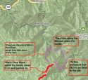
If Jon downloaded this AllTrails map to his phone or if he studied it, he can see two trails heading down to the river. As
@RedHaus has shown us one is the tail-end of the
Hite's Cove Trail. The other trail, also unmarked, is Savage Lundy. I'm not sure at this point Jon was planning a loop hike, although the map shows a loop is possible. On the description and map, the only hike is Hites Cove Road, although the other two trails are shown.
So the family parks and heads down to the river. Once there, I believe, they were hot, tired, spooked. It was much harder than they anticipated. The river is a relief, if only because there is more vegetation there. If Jon downloaded the map (or working from memory), he knows there are 3 choices. Long trail to the highway. Back the way they came. Or hug the river south to the next trail. THAT trail looks a wee bit shorter. The switchbacks appear easier. AND it's shown as a shade greener on the map. They can store energy near the river, then make a push for it up. And hopefully, the up will be less steep than the way they came down. At this point, I believe they were unaware of how debilitating the heat was. Just uncomfortable.
Jon had no information about the burnt-out, south-facing SavageLundy Trail. All he had, if he had anything, I imagine, was this map. And they took a gamble. I would have done the same thing. I have done the same thing! Thought I was making a smart decision even though I didn't have all the facts. It's what problem-solvers do all the time.
Look at the map from AllTrails for the Hites Cove Road (big red line), and see what you think. markings are mine.


") ) have assumed the "loop" LE initially considered the family did, entails some road / trail along the river that we now realize is NOT part of either the Hite Cove OHV Trail (the one that starts up at Hite Cove Road and continues down towards Route 140) or the Savage Lundy Trail.
) have assumed the "loop" LE initially considered the family did, entails some road / trail along the river that we now realize is NOT part of either the Hite Cove OHV Trail (the one that starts up at Hite Cove Road and continues down towards Route 140) or the Savage Lundy Trail.