- Joined
- Apr 16, 2018
- Messages
- 943
- Reaction score
- 10,140
dp


Looking up from the river to the top of Devil's Gulch, one would understand a significant change in elevation, the hike DOWN into the deep canyon on any trail would signify a steep climb back out. The switchbacks on SL might make the change in elevation slightly easier, in fact.
Looking down into the canyon from HC also makes the depth clear, there are many photos, GE and a reviews on AT and elsewhere of people turning around. So I don't think it was a surprise. I think that it can be easy to overestimate ability to handle a factor such as heat but the human body and canines are simply not designed to discharge heat when the core temp starts to be too elevated. It causes brain damage and organ failure. With the direct sun, not only was the air temp 109+ but the canyon would also be radiating heat up, SAR dogs burned their paws on the trail and had to be pulled. I suspect, like Kreycik, they were moving quickly and when they found themselves becoming impaired due to heat they were too far from help with no one around (as others were not on that trail in August, they were not found for days). MOO. How heat can make your body melt down from the inside out (theconversation.com)
"But when this temperature gradient is reduced, for example due to an increase in temperature and humidity, your body has a harder and harder time getting rid of this heat fast enough. And it’s a poorly recognised fact that, just like paper, our vital organs have an equivalent self-combustion point - that is, a temperature that they stop working.
Once your core body temperature reaches 40°C, your organs begin to fail, and unless you get into cooler conditions immediately, you will die."
14 heat safety tips for L.A. hiking during hot weather - Los Angeles Times (latimes.com)
I suspect their house had air conditioning and they drove to the trail in an air conditioned truck. It was very hot in the preceding days, 105 on Saturday, so the temps were not a surprise, but rather, minimized or discounted or not particularly factored in, as with Kreycik. It was possibly more about trail location and wanting to get a hike in, perhaps. Humans need to be better educated about the dangers of heat. Ironically, per someone who looked it up, it was hotter in DG that day than when they were on their adventure tour in Gobi. But they did not think about it the same way, nor were there guides or safety protocols built in. Humans also discount risk closer to home and per SAR more rescues are needed for those on day trips than overnights, again the perception of danger is different > more risks discounted or not planned for. MOO.
I agree with part, and here's my space....
They might only have planned on the HC Trail. They may not have intended to do a loop. They might not have had a bigger map than just that trail. They might not have researched any others. They might have glanced vaguely over the area on a map and registered more trails, but got the location wrong... This would explain why no one can imagine why they'd choose to do a loop. IMO that wasn't the plan. They decided when they got to the bottom of HC to do something different, but they didn't have the necessary map to make informed decisions. They followed their noses to the "wrong" trail.
IMO they got to the bottom of HC trail and maybe thought it was too dangerous/hot? to go back up.
Interesting trail descriptions From MariposaTrails.org
- South Fork Trail between Hite Cove Road trail and Savage Lundy:
Hiking this trail from June through September, or when the temperature is hot (generally above 80-degrees Feirenhit), is NOT advised. Of the entire South Fork Trail, this segment was in the worst shape. Thanks to the work of a CCC crew in April/May 2021, this segment is now in great shape.
- Savage-Lundy Trail:
Hiking this trail from June through September, or when the temperature is hot (generally above 80-degrees Feirenhit (sic)), is NOT advised. This is a great foot trail with extensive vistas of Devil's Gulch and the South Fork Merced River drainages, especially after the 2018 Ferguson Fire striped the entire hillside of vegetation, making an incredibly stark landscape. In 2021, however, the vegetation came back- and then some, with chaparral growing extensively on the trail. Unless removed, this vegetation will completely impede travel by 2022.. The elevation change is steep; best to avoid the hot mid-day while climbing out of the canyon. In April 2021, the trail washout at the bottom was repaired, but the tread is very narrow. This trail needs immediate work. Contact Mariposa Trails if you'd like to help restore this trail. . . .In April 2021, the trail washout here was repaired, but it's narrow- unusable for equestrians. Cyclists will need to carry bikes through this 30-foot segment.
- Hites Cove Road (they label it an "access road")
Most light trucks and SIV's can travel on this dirt road. Passenger vehicles should not use this road. The road is frequently covered in snow during the winter.
So back to square one which is why choose the Road and, not as others above have asked, Savage-Lundy to start with?
. My question here is what caused them to lose their ability to protect themselves and their vulnerable dependents to start that hike in the first place when they should have been of sound mind at that time?
I gave the name of the trail in thread one, or at least two when the Chronicle first published the map. It wasn't difficult to find.Hooray, @Han! Thanks for the name South Fork Trail and for the Sierra Club article. I really enjoyed it and loved getting the hiker-eye view of the SL Trail in 2015-- and those pines that need fire to reproduce. 2 questions: the hikers never made it to Peachtree Bar, I think. Sounds like they just hiked along the River some. I was disappointed. I know more about bars than hikes. Also, from start of article the hike is stated to be 7.9 mi. I assume that is round-trip but don't know for sure.
I am aware of a memorial to the ill-fated Donner Party, their wagon train of 80 pioneers stranded during a brutal Sierra winter 175 years ago. Or a lovely memorial shelter at Muir Pass for John, ‘Father of the National Parks’. There are various monuments for the heroic efforts of SAR personnel giving their life in the saving of others. And memorial groves in honor of generous benefactors donating land for public use.
I am not aware, however, of any memorials to the dozens of souls who perish yearly in our mountains due to accident. As tragic as this event is, I am uncertain what we would be lionizing.
Yes - I’m saying there is no ‘loop’ and little or no reviews or discussions about the SL Trail anywhere on the internet. There’s loads of reviews and stuff about HC trail. There is no sense or reason to them deciding to do the so-called ‘loop’ with a baby and a dog. Maybe if it was just a couple of avid hikers yes - but it’s not a family outing in my opinion. MOO
IMO they didn't decide to do a loop before they set out. They may have walked in a loop, but I don't believe that was the plan. I don't think intelligent people would choose that loop, let alone in those conditions, and they seem to have been intelligent people.Yes - I’m saying there is no ‘loop’ and little or no reviews or discussions about the SL Trail anywhere on the internet. There’s loads of reviews and stuff about HC trail. There is no sense or reason to them deciding to do the so-called ‘loop’ with a baby and a dog. Maybe if it was just a couple of avid hikers yes - but it’s not a family outing in my opinion. MOO
IMO Once they were down by the river, they thought the risk was lower than to retrace their steps up the HC trail. But they also had no mapping information that would have told them otherwise.I don’t believe they would take those risks with Miju and Oski in those circumstances.
IME One reason you see so many trails out West that have switchbacks (compared with east that has atrociously few) is that trails were used for stock. They would historically have been hauling mining gear and supplies in and out of these canyons. Same with a cavalry unit. They had horses. They need switchbacks.Some history of the Savage Lundy Trail.
Sierra National Forest (N.F.), Land and Resource(s) Management Plan (LRMP) EIS F, Fapp; Public Comments
South Fork was administered by the U.S. Cavalry (1890-1906) and the Iron, Savage Lundy, and Skeleton Creek Trails were built by the Cavalry in 1903-1904 to deal with increasing grazing and logging encroachments on the public domain. The area is the subject of a book, Treasures of the South Fork (1983), which outlines numerous special qualities of the river, particularly its Indian and early white history.
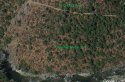
You can see the trail along the river between the HCT and SLT with Google Earth. In this image you see the Hites Cove OHV road above, the river below, and in between you can see the trail that goes from the OHV road down to the river and on to the Savage Lundy Trail. The Mariposa Trails Org mentions doing work on this unnamed trail after the fire (thanks OP who's name I forgot).That is a very good question, @Pumphouse363. Many of us, if not all (I need to be careful assuming what Lurkers think, so sorry if I don't know since you guys don't say anything,) have assumed the "loop" LE initially considered the family did, entails some road / trail along the river that we now realize is NOT part of either the Hite Cove OHV Trail (the one that starts up at Hite Cove Road and continues down towards Route 140) or the Savage Lundy Trail.
Has anyone been there to tell us what's there along the river between the 2 trails, or have access to any detailed mapping software to inform us or pictures from hikers?
Interesting trail descriptions From MariposaTrails.org
- South Fork Trail between Hite Cove Road trail and Savage Lundy:
Hiking this trail from June through September, or when the temperature is hot (generally above 80-degrees Feirenhit), is NOT advised. Of the entire South Fork Trail, this segment was in the worst shape. Thanks to the work of a CCC crew in April/May 2021, this segment is now in great shape.
- Savage-Lundy Trail:
Hiking this trail from June through September, or when the temperature is hot (generally above 80-degrees Feirenhit (sic)), is NOT advised. This is a great foot trail with extensive vistas of Devil's Gulch and the South Fork Merced River drainages, especially after the 2018 Ferguson Fire striped the entire hillside of vegetation, making an incredibly stark landscape. In 2021, however, the vegetation came back- and then some, with chaparral growing extensively on the trail. Unless removed, this vegetation will completely impede travel by 2022.. The elevation change is steep; best to avoid the hot mid-day while climbing out of the canyon. In April 2021, the trail washout at the bottom was repaired, but the tread is very narrow. This trail needs immediate work. Contact Mariposa Trails if you'd like to help restore this trail. . . .In April 2021, the trail washout here was repaired, but it's narrow- unusable for equestrians. Cyclists will need to carry bikes through this 30-foot segment.
Shorter, steeper trails are cheaper, but the steepness limits how much a person or beast can carry. There's also the risk of injury to beasts or people from falls if descending a steep trail. So at some point they decided on a grade that was optimum, and engineered trails to that grade. If the slope is steeper, you need switchbacks to reduce it. Modern railroads and highways use switchbacks, even though it's more expensive. The latest trail design guidelines for hiking use switchbacks to reduce trail maintenance and erosion. A good example is at Olompali State Park. They replaced a steeper trail to the summit of Mt Burdell with a lot of switchbacks. I don't like it because it makes the trail a lot longer, but I guess I'm an old crank.IME One reason you see so many trails out West that have switchbacks (compared with east that has atrociously few) is that trails were used for stock. They would historically have been hauling mining gear and supplies in and out of these canyons. Same with a cavalry unit. They had horses. They need switchbacks.
Trails (e.g. PCT) are also wider out west for this reason.
Consider that there are few roads in all these wilderness areas, but there was logging, mining, all kinds of activity that was facilitated by mule trains.
I was on a backpacking trip with the Sierra Club once where we were re-supplied by mule train. (Heck, I was on another one in Yosemite in the corner not too far from S-L and Hites Cove, where we were assigned to a ranger for trash pick up and trail repair, and got our re-supply by helicopter drop).
Anyway, West coast trails are REALLY different from east coast trails. This was a matter of historical function. IME.
It was noted on an earlier thread that Jon was a member of the Mariposa Trails FB group. The descriptions seem fitting, except it was 30 degrees + hotter than the temps where use of the trails was said to be ill advised. I think they underestimated the risks of the heat and overestimated their ability to push through. MOO. I don't think up and back on either trail on that day would have been notably safer, the heat in the canyon and the strenuous hike out from bottom of the canyon on any trail were the issues.
That question only applies if they wanted to take the entire loop in the first place. For a down and back to the river, I think they would have chosen the more *popular* and scenic HC Trail. Just MOO
This a reply to @MrsEmmaPeel
- Hites Cove Road (they label it an "access road")
Most light trucks and SIV's can travel on this dirt road. Passenger vehicles should not use this road. The road is frequently covered in snow during the winter.
So back to square one which is why choose the Road and, not as others above have asked, Savage-Lundy to start with?
Thank you, great find, most informative.Interesting trail descriptions From MariposaTrails.org
- South Fork Trail between Hite Cove Road trail and Savage Lundy:
Hiking this trail from June through September, or when the temperature is hot (generally above 80-degrees Feirenhit), is NOT advised. Of the entire South Fork Trail, this segment was in the worst shape. Thanks to the work of a CCC crew in April/May 2021, this segment is now in great shape.
- Savage-Lundy Trail:
Hiking this trail from June through September, or when the temperature is hot (generally above 80-degrees Feirenhit (sic)), is NOT advised. This is a great foot trail with extensive vistas of Devil's Gulch and the South Fork Merced River drainages, especially after the 2018 Ferguson Fire striped the entire hillside of vegetation, making an incredibly stark landscape. In 2021, however, the vegetation came back- and then some, with chaparral growing extensively on the trail. Unless removed, this vegetation will completely impede travel by 2022.. The elevation change is steep; best to avoid the hot mid-day while climbing out of the canyon. In April 2021, the trail washout at the bottom was repaired, but the tread is very narrow. This trail needs immediate work. Contact Mariposa Trails if you'd like to help restore this trail. . . .In April 2021, the trail washout here was repaired, but it's narrow- unusable for equestrians. Cyclists will need to carry bikes through this 30-foot segment.
- Hites Cove Road (they label it an "access road")
Most light trucks and SIV's can travel on this dirt road. Passenger vehicles should not use this road. The road is frequently covered in snow during the winter.
So back to square one which is why choose the Road and, not as others above have asked, Savage-Lundy to start with?
The person who researched the Hites Cove Trail.Who would be responsible for the decision to make the hike and take the family in your opinion?
That then begs the question....if they KNEW SL was *not a good idea*, why would they make the decision to hike along the river and back up SL? Better to simply go back up HC?My point is-- if Jon had used something other than AllTrails (ie MariposaTrails.org or topo maps) he'd have seen that SL is the hiking trail down to South Fork. Perhaps if they'd started on SL they'd have realized straightaway that the hike was not a good idea. MoO is that they took Hite Cove Road because of AllTrails. But all guesswork.
Because they didn't know..... If they were intimidated at the thought of going back up HC, they might have remembered that there was another trailhead at their truck. So, they imagined they could get there a different way than the way they came down, namely HC. But they didn't have information, reliable map, any of that....That then begs the question....if they KNEW SL was *not a good idea*, why would they make the decision to hike along the river and back up SL? Better to simply go back up HC?