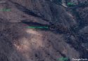
So @rahod1, this is a very helpful graphic, but it is of Hite Cove Trail to Hite Cove - where the family did not hike that day (that we know of!).
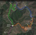
Your intent though may be just to provide us with a reality check that if the family had continued on the Hites Cover OHV Trail rather than go South/West along the South Fork Merced River, it would have added 8 miles - and would likely not have saved them. So for comparison, can you do the same with two other scenarios:
1) the suspected (by LE) loop of Hites Cove OHV Trail to some unnamed river road along the South Fork Merced to Savage-Lundy trail, and
2) Hites Cove OHV Trail until it terminates at the far right point of your red line here, down to the Hites Mine Trail to Route 140 (down those switchbacks)?
I think it would be helpful to get a sense of the distance we are talking about in that heat, as to what would have been reasonable alternatives or perhaps initial plans?
Yes.....that was my intent, to show it would still be arduous. However, it would have added a NET of 3 miles because from the juncture to the river from HC trail along the river South to the end of SL was still another 5 miles ( 2 miles on river South and 3 miles up SL). They were found 3.5 miles into that hike. Having said that, the HC NORTH to the 140 would be along the river all the way....so it's possible it would have saved them IF they would have utilized that resource for cooling.
Last edited:
") minding its own business. But who knows? Maybe the owl did do it. . .
minding its own business. But who knows? Maybe the owl did do it. . .