Just out of curiosity – I am basing this question off of the original story of Kam and Bryer heading to Whitehorse .....
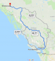
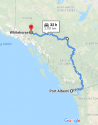
When I type into Google Maps, there are 3 routes from Port Alberni to Whitehorse. A trip through Liard Springs is not one of them, I had to physically move the cursor to change the route.
Furthest up I have been was as far as Terrace. So, for those of you who have travelled up through the far north, is there a vast difference of the 4 routes, other than time (single/divided highway, terrain, views, etc) to make one more preferable than the other?
I'm including 2 screen grabs of the route maps. The first one, the blue route is the quickest. The second one is through Liard (the one I actually had to move the cursor for) and is basically the same time (though more mileage). But if these 2 dudes, who apparently never travelled before, punched into Google or GPS, it should show the same as I got in pic 1, so how would they even know if there was a (possibly) better route?
What are your opinions or speculations on the route they chose?


")