- Joined
- Oct 31, 2016
- Messages
- 1,194
- Reaction score
- 3,906
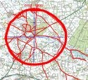
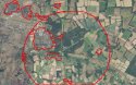
Take another look at my map. I've put it together with the information that has been supplied and summized. The large red circle is a radius of the Barton Mills mast. It was stated that the phone last pinged inside this area before it died. The red lines are the possible routes taken by the phone into it from BSE.
Question:
1. Why would the mobile phone have been taken along this directional path(s)?
2. What conurbations are relevant to this case inside or near to the circle?
These question are relevant but obviously separate to where Corrie may be.