Australia Claremont Serial Killer, 1996 - 1997, Perth, Western Australia - #17

DNA Solves
DNA Solves
DNA Solves
Status
Not open for further replies.
It appears in this article that Police have ruled out an innocent explanation to Julie Cutler's disappearance, simply because her body did not wash up upon the beach?

http://thewest2.smedia.com.au/Olive...px?href=WAN/2008/12/05&id=Ar00700&sk=1889EBF6

Yet, that is exactly what they put to the Coroner at Robyn Santen's inquest.

It would appear that it is a logical fallacy to assume that the lack of a body in cases of disappearances at beaches determines whether foul play was involved or not.

There was mention of a telephone call after Julie Cutler's disappearance. I think we need to know a bit more about this.
Was it a verified report in MSM?
If so, is there some way to find out if it was a prank?

There was mention by the coroner at Santen's inquest that there was history of bodies being lost to the ocean and not washing up but in Cutler's case, I believe a detective linked the washing up of the back seat as indicative that Julie's body should also have been returned to the shore on the same ocean patterns along with personal items in the car such as her handbag and shoes etc, none of which was recovered.
 
Someone on Bigfooty made mention of JC, being in Coober-peedy, which was odd. It seemed to be a fleeting comment.
Only mention of any Cutler there is a Port Augusta Council minutes from 2006 about a Hilda Cutler. Not much to go on.

Seems that her family have set themselves up in Kalgoorlie for the long haul.
http://www.abc.net.au/heywire/stories/2002/12/763958.htm#.WeF14MvmjqA

There is no indication that this caller to the West Australian ever called back, nor called the family or police.

On 5/12/2008 there was a memorial function at Iona Presentation, and only this year her father and one of her step sisters were in the media about the case.

If the 1988 caller claiming to be Julie, was concerned for her father's anguish, and was indeed Julie, then I would've expected further contact when it was apparent, with these later activities, that the call to the newspaper hadn't extinguished her family's anguish.

Sent from my HTC 2PQ910 using Tapatalk
 
No Ankatel is one of my spots for SS. I dont know anything about capt. whoever. The Bellevue guy who went missing after inheriting $10,000 cash. Well I still recon he is between Clayton off ramp & the Gt. Eastern Bypass turnoff. And if I ever go bushwalking again I am going to wear my Ksubi jeans. They fit like a glove & can keep ticks out. My leg is still sore from last Saturday when a tick lached onto me. Thatwas in Stoneville.
 
No Ankatel is one of my spots for SS. I dont know anything about capt. whoever. The Bellevue guy who went missing after inheriting $10,000 cash. Well I still recon he is between Clayton off ramp & the Gt. Eastern Bypass turnoff. And if I ever go bushwalking again I am going to wear my Ksubi jeans. They fit like a glove & can keep ticks out. My leg is still sore from last Saturday when a tick lached onto me. Thatwas in Stoneville.
Top tip PCS....when out in the bush, wear a lightweight onesie. A circle of Vicks Vapour Rub around your throat, wrists & ankles all prevent ticks. Tiger balm will also do the same

Sent from my SM-G930F using Tapatalk
 
Just a thought: In Parkerville there’s Sunseekers nudist camp and the amphitheatre in Parkerville has been mentioned beforehand. Apparently Sunseekers is within a fairly secluded area, and has a membership. We’ll need someone to go inside and check out the camp – PCS you’ve been nominated for that task.

Send Spooks he's invisible.
 
No Ankatel is one of my spots for SS. I dont know anything about capt. whoever. The Bellevue guy who went missing after inheriting $10,000 cash. Well I still recon he is between Clayton off ramp & the Gt. Eastern Bypass turnoff. And if I ever go bushwalking again I am going to wear my Ksubi jeans. They fit like a glove & can keep ticks out. My leg is still sore from last Saturday when a tick lached onto me. Thatwas in Stoneville.
Lightweight onesie....available for Bunnings.....painters suit

Sent from my SM-G930F using Tapatalk
 
No Ankatel is one of my spots for SS. I dont know anything about capt. whoever. The Bellevue guy who went missing after inheriting $10,000 cash. Well I still recon he is between Clayton off ramp & the Gt. Eastern Bypass turnoff. And if I ever go bushwalking again I am going to wear my Ksubi jeans. They fit like a glove & can keep ticks out. My leg is still sore from last Saturday when a tick lached onto me. Thatwas in Stoneville.
OK. do you mean The Spectacles, or Anketel? The former poster that talked about Claremont Ghost clues would appear to have focused on the road near the cement factory opposite the spectacles.
7ed55859cb07c18705a2513d92351668.jpg


Sent from my HTC 2PQ910 using Tapatalk
 
I agree there was a weak cold front over the south west of Perth, but the isobar was still 1012 hardly low or very low. That is a high pressure system of 1016 over shark bay in your image not a cold front as you said in your post above. It is clearly shown in my map of 17th June. I'm not sure if your image is of the same day, although similar. It is basic Yr 10 geography. I'm just trying to put the correct facts out there are make sure they do not get distorted.

Metic you have been quoting of random 7 m swells and NW winds off Cape Naturaliste way off of lower south west of WA. That is incompatible winds and swell size as reported for Perth metropolitan on the dates around JC's disappearance

Sorry PD, high pressure systems are anti clockwise, but the weather does move west to east as a system. All the coloured maps you posted metic clearly show a very low pressure system or very very low around 41 or 42 degrees South, so half way to Antarctica around 17th June 1988. That takes about 6 days to arrive in Perth on Friday 24th June.

attachment.php

Source West Australian Sat 18th June 1988

Saturday 18[SUP]th[/SUP] June 1988: Morning showers. Outlook fine. Temp 14 – 20. A high pressure ridge was located across the centre of the continent and was producing fine clear conditions with easterly winds in the northern half.
Extended forecast
As the high pressure ridge moves further southwards a return to fine conditions in inland areas should result by this afternoon. Coastal regions should experience isolated showers early this morning. Another weak front should pass near the southwest corner tomorrow, but showers associated with this system should be confined to the far southwest coast.

Sunday 19[SUP]th[/SUP] June 1988: Temp min 13.6 at 8.50 pm and max 20.6 at 11.45 am.
Monday 20[SUP]th[/SUP] June 1988: Temp min 10.7 at 7.30 am and max 18.4 at 2,25 pm. SW winds at 10 to 15 knots easing to 10 knots by late morning.
Tuesday 21[SUP]st[/SUP] June 1988:
Forecast Perth fine and cool. North East winds 5 to 12 knots. Seas should be 0.5 m on a swell to 2.5 m. Temp 8 – 19 degrees.

Extended forecast: With a high pressure cell establishing itself over the southern half, fine conditions should persist over the State until late tomorrow. A front should approach the coast tomorrow night and cross the lower west coast on Thursday.

Wednesday 22[SUP]nd[/SUP] June 1988: Forecast Fine. Outlook showers developing. Temp 10 – 20.
Fine and sunny conditions prevailed through the northern half, while the southern half experienced similar conditions at 4.00pm yesterday. A high pressure system was located over the Eucla and is presently bringing fine weather to almost the whole state. These conditions should persist except for the extreme SW corner where isolated showers are forecast. With clear skies and light winds inland areas should be in for another cold night with local frosts in the southern half. The seasonal fine weather should persist in the northern half.

Source: The West Australian June 17th - 22nd June 1988.

Quote
"It is basic Yr 10 geography. I'm just trying to put the correct facts out there are make sure they do not get distorted"

Quote
"All the coloured maps you posted metic clearly show a very low pressure system
Rsbm......
That takes about 6 days to arrive in Perth on Friday 24th June."
________________________________


Well the correct information has been posted for 6months .
We have been covering the finer aspects as time goes on .
Ive been patient with the countless attempts to discredit my information .

Now strangely this latest disagreement , is the 17th june weather ? ? ? ! Watever .

Even though JC went missing on the 20th .

Its obvious that the days that need the magnifying glass are 20-22 june and perhaps the few days after .
In case of evidence being retrieved .
Ive explained why i looked at the preceding days weather already .


I have been known in my field of work as the best in Australia at ocean weather forecasting since 2009 when professionals first found out my skills .
Since then ive had increased clientele and give information to amateurs & proffesionals including internationals .

If you dont believe me , well its no use asking anyone else about this weather because i have No Superiors .
Any weather expert on earth who can add to this is only one of my peers .
So if you dont believe me theres nothing i can do about it , cant call in the top oceanographer to support me because they know im as expert as they are .
 
I agree there was a weak cold front over the south west of Perth, but the isobar was still 1012 hardly low or very low. That is a high pressure system of 1016 over shark bay in your image not a cold front as you said in your post above. It is clearly shown in my map of 17th June. I'm not sure if your image is of the same day, although similar. It is basic Yr 10 geography. I'm just trying to put the correct facts out there are make sure they do not get distorted.

Metic you have been quoting of random 7 m swells and NW winds off Cape Naturaliste way off of lower south west of WA. That is incompatible winds and swell size as reported for Perth metropolitan on the dates around JC's disappearance

Sorry PD, high pressure systems are anti clockwise, but the weather does move west to east as a system. All the coloured maps you posted metic clearly show a very low pressure system or very very low around 41 or 42 degrees South, so half way to Antarctica around 17th June 1988. That takes about 6 days to arrive in Perth on Friday 24th June.

attachment.php

Source West Australian Sat 18th June 1988

Saturday 18[SUP]th[/SUP] June 1988: Morning showers. Outlook fine. Temp 14 – 20. A high pressure ridge was located across the centre of the continent and was producing fine clear conditions with easterly winds in the northern half.
Extended forecast
As the high pressure ridge moves further southwards a return to fine conditions in inland areas should result by this afternoon. Coastal regions should experience isolated showers early this morning. Another weak front should pass near the southwest corner tomorrow, but showers associated with this system should be confined to the far southwest coast.

Sunday 19[SUP]th[/SUP] June 1988: Temp min 13.6 at 8.50 pm and max 20.6 at 11.45 am.
Monday 20[SUP]th[/SUP] June 1988: Temp min 10.7 at 7.30 am and max 18.4 at 2,25 pm. SW winds at 10 to 15 knots easing to 10 knots by late morning.
Tuesday 21[SUP]st[/SUP] June 1988:
Forecast Perth fine and cool. North East winds 5 to 12 knots. Seas should be 0.5 m on a swell to 2.5 m. Temp 8 – 19 degrees.

Extended forecast: With a high pressure cell establishing itself over the southern half, fine conditions should persist over the State until late tomorrow. A front should approach the coast tomorrow night and cross the lower west coast on Thursday.

Wednesday 22[SUP]nd[/SUP] June 1988: Forecast Fine. Outlook showers developing. Temp 10 – 20.
Fine and sunny conditions prevailed through the northern half, while the southern half experienced similar conditions at 4.00pm yesterday. A high pressure system was located over the Eucla and is presently bringing fine weather to almost the whole state. These conditions should persist except for the extreme SW corner where isolated showers are forecast. With clear skies and light winds inland areas should be in for another cold night with local frosts in the southern half. The seasonal fine weather should persist in the northern half.

Source: The West Australian June 17th - 22nd June 1988.

"Metic you have been quoting of random 7 m swells and NW winds off Cape Naturaliste way off of lower south west of WA.
That is incompatible winds and swell size as reported for Perth metropolitan on the dates around JC's disappearance"

_______________________________

Have a read of this article, hopefully you will begin to understand how mega swells affect the west oz coastline .
Its plainly obvious in this article !

Quote from the article below :

"Mr Vivers said these swells, which accumulated energy and travelled at breakneck speed, could create waves of once-in-a-decade sizes across the southern half of WA."

"He expected Perth beaches to get waves of up to perhaps eight feet while*south-west towns such as Margaret River can expect*20 to 25-foot swells."

"Swells of up to 50 feet could strike more exposed stretches of coast."
"Perth's Scarborough Beach was dotted by hundreds of surfers on Friday morning."
"He said these swells, though much desired by big wave riders, could be dangerous for inexperienced surfers or swimmers and rock fishers around Perth, Rottnest, Albany and all the way up the coast to Geraldton.
They would probably reach Exmouth by Saturday."
"There will be risk of beach erosion around places like Trigg and Scarborough, even Cottesloe, and places such as Lancelin and Seabird," he said"
"Mr Majeks said prospective spectators could head just about anywhere – Cottesloe, Leighton, City, Trigg, Ocean Reef or Two Rocks beaches, to name a few."

http://www.watoday.com.au/wa-news/o...vour-to-west-australians-20150625-ghxlrb.html

________________________________

Extra Articles from the same event in june 2015 .

https://www.swellnet.com/news/swell...indian-ocean-mega-swell-hits-indonesia-photos

https://www.swellnet.com/news/swell...cean-mega-swell-hits-western-australia-photos
 
Again i will try to spotlight the enormity of a swell reading 5, 6 & 7 metres .

These articles are about a swell of 5.5m
One articles says that metro beaches did not recieve much swell due to the southwest direction .

The event relative to JCs car was a very favorable Direction for cottesloe / metro beaches to recieve the swell as the direction was coming in from the north west (seen on my links).
On the occasion preceding the 20th june "88 the evidence shows that cott beach was recieving 2.5 -3 metres of swell .

As the article says that is Rare .
They say "once in a decade" type conditions .

"A five-and-a-half-metre swell was recorded at the Cape Naturaliste buoy, 14 kilometres west of Dunsborough, at midnight."

http://mobile.abc.net.au/news/2015-06-26/wa-surfers-enjoy-big-swell/6575754?pfmredir=sm
________________________________


Quote from the article below :

"Five- to six-metre surf buffeted by perfect offshore winds have unleashed on breaks across the coast this morning.
According to the Department of Transport buoy off Cape Naturaliste, the swell reached more than five metres with a very high 16-second swell period in the state's South West."

http://mobile.abc.net.au/news/2015-06-25/wa-surfers-gearing-up-for-swell-of-the-decade/6573912
 
I have gone to Swanbourne Beach quite a few times & have thought about joining Sunseekers..... Mapua NZ 2 visits. :)
 
Top tip PCS....when out in the bush, wear a lightweight onesie. A circle of Vicks Vapour Rub around your throat, wrists & ankles all prevent ticks. Tiger balm will also do the same

Sent from my SM-G930F using Tapatalk

If I do as you suggest ESH I might get arrested. I did once. That was in Swan View when a neighbour at # 2 fired 2 shots at where ever his wife was staying the night. I was out taking photos wondring why Morrison rd was closed down. $200 fine for that. Police State here.
 
If I do as you suggest ESH I might get arrested. I did once. That was in Swan View when a neighbour at # 2 fired 2 shots at where ever his wife was staying the night. I was out taking photos wondring why Morrison rd was closed down. $200 fine for that. Police State here.

Just keep that onesie and camera at home when you visit Swanbourne beach, or you might find how much of a Police State you are residing in.

Also, be sure to check out Met’s worlds best ocean swell forecast, so you know if it’s safe to jog along the waters edge and which way the wind is blowing.
 
In regards to Ankatel someone said Dr. P knewmore than anyon else. And he said he (Dr P) reconed SMM was at Mundaring Weir & SS was at Ankatel. Was prob in the Gary hughes blog, or in his ther log Has a Serial killer blogged here. BRE was forced to say something cause it was mayhem on that blog. And I think BRE did. Hence the ankatel bit. Maybe smeoe can go back and search all Gary Hughes blogs n see who said DR P was rght. I don't have time.
 
I agree there was a weak cold front over the south west of Perth, but the isobar was still 1012 hardly low or very low. That is a high pressure system of 1016 over shark bay in your image not a cold front as you said in your post above. It is clearly shown in my map of 17th June. I'm not sure if your image is of the same day, although similar. It is basic Yr 10 geography. I'm just trying to put the correct facts out there are make sure they do not get distorted.

Metic you have been quoting of random 7 m swells and NW winds off Cape Naturaliste way off of lower south west of WA. That is incompatible winds and swell size as reported for Perth metropolitan on the dates around JC's disappearance

Sorry PD, high pressure systems are anti clockwise, but the weather does move west to east as a system. All the coloured maps you posted metic clearly show a very low pressure system or very very low around 41 or 42 degrees South, so half way to Antarctica around 17th June 1988. That takes about 6 days to arrive in Perth on Friday 24th June.

attachment.php

Source West Australian Sat 18th June 1988

Saturday 18[SUP]th[/SUP] June 1988: Morning showers. Outlook fine. Temp 14 – 20. A high pressure ridge was located across the centre of the continent and was producing fine clear conditions with easterly winds in the northern half.
Extended forecast
As the high pressure ridge moves further southwards a return to fine conditions in inland areas should result by this afternoon. Coastal regions should experience isolated showers early this morning. Another weak front should pass near the southwest corner tomorrow, but showers associated with this system should be confined to the far southwest coast.

Sunday 19[SUP]th[/SUP] June 1988: Temp min 13.6 at 8.50 pm and max 20.6 at 11.45 am.
Monday 20[SUP]th[/SUP] June 1988: Temp min 10.7 at 7.30 am and max 18.4 at 2,25 pm. SW winds at 10 to 15 knots easing to 10 knots by late morning.
Tuesday 21[SUP]st[/SUP] June 1988:
Forecast Perth fine and cool. North East winds 5 to 12 knots. Seas should be 0.5 m on a swell to 2.5 m. Temp 8 – 19 degrees.

Extended forecast: With a high pressure cell establishing itself over the southern half, fine conditions should persist over the State until late tomorrow. A front should approach the coast tomorrow night and cross the lower west coast on Thursday.

Wednesday 22[SUP]nd[/SUP] June 1988: Forecast Fine. Outlook showers developing. Temp 10 – 20.
Fine and sunny conditions prevailed through the northern half, while the southern half experienced similar conditions at 4.00pm yesterday. A high pressure system was located over the Eucla and is presently bringing fine weather to almost the whole state. These conditions should persist except for the extreme SW corner where isolated showers are forecast. With clear skies and light winds inland areas should be in for another cold night with local frosts in the southern half. The seasonal fine weather should persist in the northern half.

Source: The West Australian June 17th - 22nd June 1988.
These news articles also point out the rarity of 5 , 6 & 7 metre swells !

"Bureau of Meteorology duty forecaster Paul Vivers said the swell has been on the rise throughout the week and should peak on Friday around five to six metres.
Mr Vivers said these conditions were a very rare occurrence."

"This kind of swell, combined with light winds and huge wave periods, are seen once every 10 years."

http://www.watoday.com.au/wa-news/m...garet-river-and-wa-coast-20150625-ghxrwq.html
 
There's doesn't seem to be much at Swanbourne. What about BRE being in the army reserves?

There's a section of the army near Graylands Hospital in Brockman Rd.
 
These news articles also point out the rarity of 5 , 6 & 7 metre swells !

"Bureau of Meteorology duty forecaster Paul Vivers said the swell has been on the rise throughout the week and should peak on Friday around five to six metres.
Mr Vivers said these conditions were a very rare occurrence."

"This kind of swell, combined with light winds and huge wave periods, are seen once every 10 years."

http://www.watoday.com.au/wa-news/m...garet-river-and-wa-coast-20150625-ghxrwq.html

Met has given us some brilliant lessons in Meteorology IOI, a precis could be 'Given all the information available at any specific time this is the predicted outcome. But due to known or unknown variables that can occur unexpectedly the forecast doesn't always match the weather,wave swells etc on the day)

However the car got there, it was in the water.

If JC was in the car she could have possibly been washed out of it. Then she would have been washed out to sea or washed up on the shore. She hasn't been found washed up and most likely would never be found at sea.

If JC wasn't in the car then the weather is of no consequence now.

Just my thoughts on the matter.
 
Met has given us some brilliant lessons in Meteorology (my SNIP)

If JC wasn't in the car then the weather is of no consequence now.

Catching up on this thread and walking round this chat room when things get a wee off track, has got me singing "Stormy Weather".

The number 57 has no relevance, but Mt Pleasant could have been a fishing haunt of the CSK accused in his pursuit of black bream, mulloway, flathead, yellowtail grunter, crabs and river prawns.

Will the accused CSK "lie like a loungeroom lizard"
or "sing like a bird released"?

I hope it's the latter. And soon!
 
Met has given us some brilliant lessons in Meteorology IOI, a precis could be 'Given all the information available at any specific time this is the predicted outcome. But due to known or unknown variables that can occur unexpectedly the forecast doesn't always match the weather,wave swells etc on the day)

However the car got there, it was in the water.

If JC was in the car she could have possibly been washed out of it. Then she would have been washed out to sea or washed up on the shore. She hasn't been found washed up and most likely would never be found at sea.

If JC wasn't in the car then the weather is of no consequence now.

Just my thoughts on the matter.

Quote janwa:
"But due to known or unknown variables that can occur unexpectedly the forecast doesn't always match the weather,wave swells etc on the day)"

Thats right janwa , forecasts are predictions and the weather does not always do as experts predict .

Hindcasts are looking back at the weather thats passed .
This means using actual real true data measured by specific instruments .
Hindcasting is not guessing.

The hindcasting of the weather in time frame 15-26th june 1988 is what i have provided .
The buoy measurements are true statistics .
My data came from this reanalysis model… trustworthy and used in many climate studies
http://www.ecmwf.int/en/research/climate-reanalysis/era-interim


Seeing that its most likely the car went into the ocean at night ,
There is 3 nights it could possibly happen !

The first night the waves were very big, perhaps 2-3 metres , double overhead high and powerful !

The second night was much calmer with perhaps a metre of swell and fine weather .
So just medium waves no more than head high and of weak power .

The 3rd night was fine also , but this night an interesting thing occured .
About midnight a 22 second period swell arrived .
"Long period swell" as i detailed previously .


This means that waves were not tall but moving much faster than normal and very powerful .
These waves are infrequent and maybe half hr or more apart .
This is the sort that kill rock fishermen who get caught off guard .
With this information i hope that sleuths can separate the 3 different nights and evaluate the different risks involved and dangers .
Each night would be a different situation getting the car into the ocean .

My guess is the first night, but i dont have all the news reports to see clearly , read and theorize .
I hope that other sleuths would help look into that .

The 3rd night is the "dark horse" night because although conditions may have seemed fine they were actually dangerous from about midnight , to at least dawn to midday due to the "long period swell"

http://www.websleuths.com/forums/showthread.php?p=13680872
 
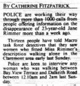
IC - heres one link to the "13 sightings" of JR article. Posted by Sutton #65
http://www.websleuths.com/forums/sh...er-1996-1997-Perth-Western-Australia-11/page6

Interesting JC discussion back on thread 2 - near the front I think.

Thanks no name. 13 people told Macro they saw women fitting Jane's description walking along Stirling Hwy. They want to talk to any women who may have been walking between Bay View Tce and Dalkeith Rd between 12.10 am and 2.00 am last Sunday. However I did get sidelined at the start of Thread 2!!! Some very interesting information and links coming out there.

attachment.php
attachment.php

Source 1 West Aust June 1996 2. Google Maps
 

Attachments

  • JR_13_sightings.JPG
    JR_13_sightings.JPG
    88 KB · Views: 127
  • JR_BayView_DalkeithRd.jpg
    JR_BayView_DalkeithRd.jpg
    56.5 KB · Views: 128
Status
Not open for further replies.

Members online

Online statistics

Members online
142
Guests online
1,746
Total visitors
1,888

Forum statistics

Threads
602,110
Messages
18,134,805
Members
231,236
Latest member
craig21876
Back
Top