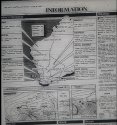
Just as well I have the real temperature for 20th June 1988, and real weather map with weather description and forecast printed in The West Australian on 21st June 1988. This is inofrmation gathered from the 20th of June and published on the 21st June 1988. As state before the West was used extensively for its forecasts and local waters forecast and I've only captured about 3/4 of what is shown on the weather page.
I've published this particular map and others here three or four times.
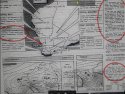
This is accurate minimum and maximum temperature for Perth 20th June 1988. The information on min temp previously published for Subiaco was 8 degrees but the West information also gives the exact time of the minimum. Each day from 20 - 22nd June the minimum was around 10 to 11 degrees and around 7 to 7.30 am. Didn't stop the bobbies turning up every morning at 7 am and didn't stop any other regulars that I knew.
The
minimum temperature for the 20 th June 1988 was 10.7 degrees at 7.30 am. This was the coldest it got any time after midnight on 20th June. The
maximum temp was 18 degrees at 2.25 pm on 20th June 1988.
I saw the original micro phish and taken notes (description below) and photos. Images I've posted three or four times now. Not sure what you are trying to gain by posting unreadable or inaccurate interpretations.
Source: The West Australian Tuesday 21st June 1988
The front was fragmented in structure and rainfall was only expected to be light in inland districts.
The front had brought one of the few SW changes in recent weeks, consequently colder air of southern origin was extending through the SW. Pressures are expected to rise rapidly behind the front and fine weather was expected to develop in the SW.
SW winds at 10 to 15 knots easing to 10 knots by late morning.