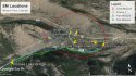
This post is an attempt to make sense of the various tidbits of information that have made mainstream news reports. Please don’t expect me to prove ANY of the MSM reports as I’m not confident in their veracity myself. All I’m trying to do is plot the information onto a map as a line of events, instead of random bursts of disconnected info. The illustration is a Google Earth Aerial View of the area, with SM’s house at 19057 Puma Path marked by a yellow pin on the extreme right. It is reported that she left about 8:00 am, proceeding toward the vicinity of the intersection of Highway 50 and County Road 225. Her neighbor JR saw her ride by her house, which is marked by another yellow pin at 19069 Monarch River Rd. I have ,marked the route in light blue line following SM’s driveway, Puma Path, and County Road 225. Just past the bridge over the South Arkansas River, marked with a yellow pin, CR 225 veers right, to rise to join Highway 50, but I have veered SM’s possible route left, following the path of service crews on the massive power line. Once the clear cut is joined, the elevation is precisely 8,850 ft. I can see how she may have planned an all-day outing, involving riding / walking all the way up the clear cut to the top, at 11,400 ft. There is a well worn path, and the exact elevation rise might be convenient for exercise calculating. I can only guess at that part because you will never see me doing this run. I’ve cut off the majority of the ascent, to keep the aerial view in reasonable perspective. But imagine that blue line going all the way up. On top, there are paths across the ridge (literally ridge at the top of Monarch) to a permanent sign marking the Fooses Lake descent. I’ve picked up the path with a neon green line near the point where I cut off on the left side of the picture. It descends rapidly to the Fooses Lake Bridge (marked with another pin), which appears to actually be a way up the canyon from Fooses Lake. Note that path path down only crosses the path up in one spot. It doesn’t cross in the hidden portion of the paths, either. That single crossing is in an open flat, severely limiting the possibility of fast moving descending bikers slamming into slow moving ascending bikers. Once past Foos Lake, SM’s path would have been on County Road 225, crossing the bridge over Fooses Creek marked with a yellow pin, and retracing her route up Puma Path and her driveway to home. Obviously, she never made it home.
So the burning question is, was her progress stopped at the bridge, and if it was, then which bridge. All three bridges are west of the highway intersection (sort of), and all three are within the 2000 feet from her house description (sort of). I’ve placed a circle red circle, which is much distorted by the landscape and angle view at the 2000 foot mark from the intersection. I need to note that the Foos Lake Bridge is really difficult to locate, and simple logic might have told a reporter that the bridge should be at the lake of the same name, which is 2000 feet. I don’t have an answer. I wish I did, because that might tell us whether she was intercepted in the morning ascent, or in the afternoon descent (or possibly never got to the point of ascent, if the object was found on or near US50 beyond where my blue line makes that sharp left turn.
Lots to think about! IMO
Screenshot created entirely by Google Earth


")