

You are using an out of date browser. It may not display this or other websites correctly.
You should upgrade or use an alternative browser.
You should upgrade or use an alternative browser.
2020 Hurricane Season Starting Early, "High Activity" Expected This Year
- Thread starter Gardener1850
- Start date
- Joined
- Feb 3, 2018
- Messages
- 20,833
- Reaction score
- 123,806
Well Marco is keeping everyone on their toes. Everyone along the coast of the GOM should be prepared. Water is the biggest risk!
Tropical Tidbits
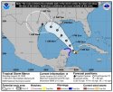
The tiny center of Tropical Storm #Marco is tracking faster to the north and to the east of what was originally expected, and looks like it will not track over the Yucatan Peninsula. Its current motion may in fact take it closer to the western tip of Cuba. Recon data indicates that Marco is quickly intensifying, which is a risk we talked about with such a small circulation. Max surface winds are now near ~65 mph, and Marco could become a hurricane later today.
Marco's faster track northward could cause the forecast track to shift a bit to the right, increasing odds of impacts to Louisiana on Monday and/or Tuesday. A faster Marco should encounter more hostile wind shear, however, and despite its current strengthening trend, weakening is likely as it approaches the US. Regardless, a heavy rainfall event at a minimum is likely in Louisiana/Mississippi and possibly portions of SE Texas.
Marco is rapidly evolving, so keep an eye out for possible changes to the forecast.
Tropical Tidbits
The tiny center of Tropical Storm #Marco is tracking faster to the north and to the east of what was originally expected, and looks like it will not track over the Yucatan Peninsula. Its current motion may in fact take it closer to the western tip of Cuba. Recon data indicates that Marco is quickly intensifying, which is a risk we talked about with such a small circulation. Max surface winds are now near ~65 mph, and Marco could become a hurricane later today.
Marco's faster track northward could cause the forecast track to shift a bit to the right, increasing odds of impacts to Louisiana on Monday and/or Tuesday. A faster Marco should encounter more hostile wind shear, however, and despite its current strengthening trend, weakening is likely as it approaches the US. Regardless, a heavy rainfall event at a minimum is likely in Louisiana/Mississippi and possibly portions of SE Texas.
Marco is rapidly evolving, so keep an eye out for possible changes to the forecast.
Attachments
- Joined
- Apr 10, 2018
- Messages
- 7,917
- Reaction score
- 62,808

- Joined
- Feb 3, 2018
- Messages
- 20,833
- Reaction score
- 123,806
- Joined
- Feb 3, 2018
- Messages
- 20,833
- Reaction score
- 123,806
I had to pick up a prescription today. Figured I'd go through the drive thru. I pull up and there's a sign, testing to the left (drive in window) and prescription pick up to the right (tube with corded phone). I watched the person in front of me pick up the phone receiver, then hang up, open his door, get the tube, pick up the phone receiver again..... um, nope'd right out of that. I walked inside and didn't touch anything but the bag they handed me. Good grief what a dumb set up. Nobody standing out there to sanitize the equipment after each person used the phone or the tube.
Maybe they thought you'd pick up your meds and go around the building and get in the testing line? Insert eye roll.
Last edited:
- Joined
- Feb 3, 2018
- Messages
- 20,833
- Reaction score
- 123,806
People have got to leave. I’m hoping those without personal transportation can get on an evacuation bus or the generosity of their neighbors will get them out.
Marco becomes a hurricane as the Gulf Coast braces for 2 cyclones this week
Marco becomes a hurricane as the Gulf Coast braces for 2 cyclones this week - CNN
The Gulf Coast will get walloped by a pair of hurricanes this week, bringing torrential rain, fierce winds and ferocious storm surges.
The National Hurricane Center warned of "life-threatening storm surge" as Marco churned closer to the Gulf Coast.
The NHC issued a storm surge warning for coastal cities from Morgan City, Louisiana, east to Ocean Springs, Mississippi.
Marco is expected to bring a storm surge height of 4 to 6 feet for Biloxi, Mississippi, and Grand Isle, Louisiana, Chinchar said.
Hurricane Marco: Public Advisory
Adv # 14 , 08/23/2020 05:00 PM EDT
...MARCO EXPECTED TO BRING LIFE-THREATENING STORM SURGE AND
HURRICANE-FORCE WINDS ALONG PORTIONS OF THE U.S. GULF COAST
MONDAY...
SUMMARY OF 400 PM CDT...2100 UTC...INFORMATION
----------------------------------------------
LOCATION...25.8N 87.8W
ABOUT 240 MI...390 KM SSE OF THE MOUTH OF THE MISSISSIPPI RIVER
ABOUT 395 MI...640 KM SE OF LAFAYETTE LOUISIANA
MAXIMUM SUSTAINED WINDS...75 MPH...120 KM/H
PRESENT MOVEMENT...NNW OR 340 DEGREES AT 13 MPH...20 KM/H
MINIMUM CENTRAL PRESSURE...991 MB...29.27 INCHES
Hurricane Marco Intermediate Advisory Number 14A
NWS National Hurricane Center Miami FL AL142020
700 PM CDT Sun Aug 23 2020
...MARCO EXPECTED TO MOVE NEAR THE LOUISIANA COAST ON MONDAY...
SUMMARY OF 700 PM CDT...0000 UTC...INFORMATION
----------------------------------------------
LOCATION...26.4N 87.6W
ABOUT 180 MI...290 KM SSE OF THE MOUTH OF THE MISSISSIPPI RIVER
MAXIMUM SUSTAINED WINDS...75 MPH...120 KM/H
PRESENT MOVEMENT...NNW OR 340 DEGREES AT 13 MPH...20 KM/H
MINIMUM CENTRAL PRESSURE...991 MB...29.27 INCHES
- Joined
- Feb 3, 2018
- Messages
- 20,833
- Reaction score
- 123,806
The lessening strength doesn’t lessen the drowning risk.
Tropical Storm Marco, no longer hurricane, set to make landfall in Louisiana
Tropical Storm Marco, which has weakened from hurricane strength, is expected to make landfall in the northern Gulf Coast Monday.
The storm is expected to make landfall in Louisiana around midday.
"Gusty winds, dangerous storm surge, and heavy rainfall are expected from Marco along portions of the Gulf Coast beginning later today,” explained the National Weather Service in an advisory. “Interests in these areas should follow any advice given by government officials.”
- Joined
- May 15, 2013
- Messages
- 55,635
- Reaction score
- 315,028
Marco hurricane warning dropped, Laura now in Gulf and could become strong hurricane
Marco has weakened even more as of 5 a.m. this morning and winds are now down to 60 mph. Marco is expected to continue weakening and Hurricane Warnings have been discontinued for the Louisiana coast.
Marco should make landfall somewhere south of Morgan City, Louisiana, late tonight as a weak Tropical Storm. Wind will not be an issue but a storm surge of 2 to 4 feet south of Morgan City is still expected. Some heavy rain is also expected with, locally, more than a half a foot possible but no major flooding is anticipated.
Laura is a different creature and is just days behind Marco. Laura continues to strengthen this morning as it passes now south of Cuba in the warm Caribbean waters with winds now 65 mph with higher gusts.
A Tropical Storm Warning has been issued for the Florida Keys due to Laura passing to the south tonight.
Once Laura emerges over the Gulf of Mexico Monday night, environmental conditions will become favorable for possible rapid intensification and Laura could become a Category 2 hurricane on Tuesday into Wednesday with winds over 100 mph.
At this moment the landfall looks like will be in western Louisiana sometime Wednesday night between Lake Charles, Louisiana and Beaumont, Texas.
Threats with Laura will include damaging winds, deadly storm surge and flooding rain.
- Joined
- May 15, 2013
- Messages
- 55,635
- Reaction score
- 315,028
Hi everyone!
I set up a separate Hurricane Laura thread since it will make landfall in the USA. STAY SAFE!
Hurricane Laura - 2020
Welcome back here for Nana.
I set up a separate Hurricane Laura thread since it will make landfall in the USA. STAY SAFE!
Hurricane Laura - 2020
Welcome back here for Nana.
- Joined
- Feb 3, 2018
- Messages
- 20,833
- Reaction score
- 123,806
Oh look.... more blowhards out there just waiting to annoy us all.... LOL! Maybe at least 1 will become a fish spinner.
Flhurricane.com
Two areas in the Central Atlantic are being watched, but are 30% and currently don't have strong model support, but are in areas where that could change,
As for Laura,
The last National Hurricane Center advisory was issued for Laura, as it moves out of Arkansas.
Laura made landfall in Cameron around 1AM on August 27th as a cat 4, shear was impacting it as it made landfall, so it was a hurricane weakening at landfall, however, it had built up quite quickly before it reached the peak only several hours before landfall. Storm surge along the coast seemed to be 9-13 feet near Cameron, and a bit higher just east of Cameron (Creole) in the area of the eyewall that had straight north winds, in that section (mostly unpopulated, the surge reached over 15ft)
The storm rapidly weakened once over land, and brought a lot of water and wind damage through Lake Charles and some north, it will be a bit before the damage extent is well known because of how much was knocked out in the area. It was significant in spots. Unlike Michael, the last major hurricane to strike the US, this one had reached its peak before landfall. Michael was still ramping up at landfall so the inland impacts were further in. Laura still did have a good impact inland as well, but it dropped off much more quickly.
The recovery effort in and well around Lake Charles is going to take some time, and many areas within the region probably have been changed forever. Towns such as Cameron, and Holly Beach, may never be the same after it. A lot of those were hit by Rita, and this was more powerful than Rita. Some of the newer structures were built better/higher after Rita, but even some of those did not survive Laura. The impact west of the landfall point fell off much more quickly.
A tropical wave located about 900 miles east of the Windward Islands is producing an area of showers and thunderstorms. Some gradual development of this system is possible during the next several days while it moves westward at about 15 mph toward the eastern Caribbean islands.
* Formation chance through 48 hours...low...20 percent.
* Formation chance through 5 days...low...30 percent.
Another tropical wave is located over the eastern Atlantic Ocean just west of the Cabo Verde Islands. The northern part of this wave, which should move rapidly westward over the central Atlantic during the next few days, is not forecast to develop as it is expected to remain in unfavorable environmental conditions.
However, the southern part of the wave is expected to be nearly stationary south of the Cabo Verde Islands for the next several days, and some development of this system is possible early next week when it begins to move slowly westward over the eastern and central tropical Atlantic.
* Formation chance through 48 hours...low...near 0 percent.
* Formation chance through 5 days...low...30 percent.
- Joined
- Feb 3, 2018
- Messages
- 20,833
- Reaction score
- 123,806
We are fresh out of landing space. This dude needs to fizzle....
Tropical Tidbits
A tropical wave passing through the Caribbean south of Hispaniola does not appear to have a closed circulation, but has a chance of becoming a tropical depression or storm before moving into Central America near Belize on Thursday. Regardless of development, heavy rains expected.
Tropical Tidbits
A tropical wave passing through the Caribbean south of Hispaniola does not appear to have a closed circulation, but has a chance of becoming a tropical depression or storm before moving into Central America near Belize on Thursday. Regardless of development, heavy rains expected.
- Joined
- Feb 3, 2018
- Messages
- 20,833
- Reaction score
- 123,806
A fish spinner... yay!
Tropical Tidbits
A weak circulation with organized thunderstorm activity is developing offshore of the Carolinas this morning, and has a chance to become a tropical depression or storm as it moves northeastward over the waters of the northwest Atlantic. It is not a threat to land.
Tropical Tidbits
A weak circulation with organized thunderstorm activity is developing offshore of the Carolinas this morning, and has a chance to become a tropical depression or storm as it moves northeastward over the waters of the northwest Atlantic. It is not a threat to land.
- Joined
- May 15, 2013
- Messages
- 55,635
- Reaction score
- 315,028
There are four tropical waves developing in the Atlantic storm basin Monday 
4 tropical systems developing in the Atlantic Ocean as record-setting hurricane season continues
A tropical wave off the Georgia coast has a 70% chance to become a named tropical storm in the next five days, but even if it does, it is supposed to continue tracking away from the East Coast.
A tropical wave in the eastern Caribbean Sea has an 80% chance to become a named tropical storm in the next five days. This system reaches more conducive conditions slightly ahead of the tropical wave off the coast of Georgia. It's moving west at 15-20 miles per hour and could strengthen in the coming days. People in Jamaica, Honduras, Belize, Guatemala and the Yucatan peninsula have been urged to keep a close eye on this system's development.
The other two tropical waves have much lower chances of developing into tropical storms in the next five days. One is located in the eastern Atlantic Ocean; the other is still forming over the west coast of Africa. At this time, both storms are just being monitored as they move west into the Atlantic Ocean.
- Joined
- Feb 3, 2018
- Messages
- 20,833
- Reaction score
- 123,806
The fish spinner is leaving us, thankfully.
NOAA NWS National Hurricane Center
...NEW TROPICAL DEPRESSION FORMS OFFSHORE OF NORTH CAROLINA BUT EXPECTED TO STAY AWAY FROM LAND...
There are no coastal watches or warnings in effect.
NHC is issuing advisories on newly formed Tropical Depression Fifteen. It's centered as of 5 p.m. EDT over the western Atlantic Ocean about 190 miles (305 km) south-southwest of Cape Hatteras, North Carolina. The depression is moving toward the northeast near 12 mph (19 km/h) and a motion toward the northeast or east-northeast is expected to occur during the next few days.
Maximum sustained winds are near 35 mph (55 km/h) with higher gusts. The depression is forecast to become a tropical storm on Tuesday. When that occurs, it will be named "Nana". Little, if any, additional strengthening is forecast to take place Tuesday night or Wednesday.
Swells generated by the depression are affecting portions of the coast of North Carolina, especially along the Outer Banks. These swells are likely to cause life-threatening surf and rip current conditions through tomorrow. Please consult products from your local weather office www.weather.gov
The next advisory will be issued by NHC at 11 p.m. EDT - www.hurricanes.gov
- Joined
- Feb 3, 2018
- Messages
- 20,833
- Reaction score
- 123,806
I wonder if this will head out to the Pacific and fire up?
Tropical Tidbits
An aircraft recon mission into the Caribbean this morning has found a closed circulation south of Jamaica. As a result, the NHC is now issuing advisories on Potential Tropical Cyclone 16 (#PTC16), forecast to become a tropical storm and impact Honduras and Belize on Wed/Thurs.
Tropical Tidbits
An aircraft recon mission into the Caribbean this morning has found a closed circulation south of Jamaica. As a result, the NHC is now issuing advisories on Potential Tropical Cyclone 16 (#PTC16), forecast to become a tropical storm and impact Honduras and Belize on Wed/Thurs.
- Joined
- Feb 3, 2018
- Messages
- 20,833
- Reaction score
- 123,806
Hopefully, everyone will be safe at the beaches. The rip currents can catch even seasoned surfers by surprise.
Nana and Omar become the earliest 14th and 15th named storms - CNN
Tropical Depression Fifteen strengthened slightly Tuesday afternoon and the National Hurricane Center upgraded it to Tropical Storm Omar. Just hours earlier, a vigorous tropical disturbance in the Caribbean became Tropical Storm Nana, according to the hurricane center.
The record-breaking hurricane season continues to churn out storms. Nana and Omar are the earliest 14th and 15th named storms in the Atlantic basin, respectively, each breaking a record from the 2005 season.
Gardenista
Well-Known Member
- Joined
- Jun 21, 2016
- Messages
- 19,034
- Reaction score
- 182,275
Fingers crossed
Similar threads
- Replies
- 7
- Views
- 2K
- Replies
- 1
- Views
- 948
Guardians Monthly Goal

Goal Reached! We hit our target of 75 new Guardians!
New stretch goal: 100!
Our goal for the month is 75 new Guardians members to sign up. Have you been thinking about becoming a member?
Click here to find out how!
Online statistics
- Members online
- 52
- Guests online
- 1,797
- Total visitors
- 1,849
Totals may include hidden visitors.
Forum statistics
Community Rules
-
Be CivilTreat all members with respect. No personal attacks, harassment, or inflammatory language.
-
Victim FriendlyAlways show respect for victims and their families. No victim blaming or insensitive speculation.
-
Fact-based SourcingProvide credible sources for claims. Distinguish between verified facts and personal theories.
-
Social Media UseDo not post direct links to personal social media profiles of private individuals.
-
Copyright and PaywallsDo not copy full articles. Summarize and link to the original source instead.
-
Privacy and Personal InformationDo not post personal information such as addresses, phone numbers, or workplaces.
-
Registered Sex-OffendersDo not name or speculate about RSOs unless officially named in connection to a case.
-
Stay On TopicKeep discussions relevant to the case or topic at hand. Avoid off-topic tangents.
-
Accounts, Moderation, and DisputesOne account per person. Contact moderators privately for disputes or concerns.
-
Solicitation and FundraisingNo solicitation, fundraising, or promotion of personal ventures without approval.