Phone Calls and Phone Records

I don't know if this is the same spot or not but here is a pic from a wacked-out, Zipper Theory, webpage sleuth....

Take note of his reference to the specific celltower IDs, and to references of specific call times. They appear to contain the registration IDs for the separate levels on a single tower. I have no idea how he managed to gather this data. Perhaps just guess work??

attachment.php

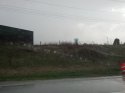
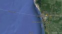
Oh--it is not the same spot for sure! I'll try to repost with the Town Names showing.

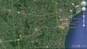
I'd like to look more closely at the source. I don't see anything that showed those locations of towers. Additionally, the separate levels of the towers are 1 Due North, 2 90° east and 3 90° west. From what I've read, it would be the 5th digit. So in the picture the 21921 she would be north of the tower and 21923 she would be west of the tower.

If you look at the map from KZ's floor and what I posted, it looks like she has focused in on an area around Route 10 and 32 or Route 55/114---due north from what I believe is SS's house. I could be wrong and that could be Route 151 (which would correspond with what I posted about the 21923 tower at Route 151 and Route 67) Its hard to tell---but--the important thing is that she is focusing in on that area.
 
Here is the same map with the names of the towns. The thumb tacks are what I believe are the towers 21923--21921--and 21101 (Although the number is 51113, I recall reading sometimes when there are multiple antennas on the same tower the 1st antenna has 1,2, and 3 and the 2nd antenna has 4,5, and 6.) So, I think the 5 represents the 2 in the 21101 tower on TH's bill. (which coincidentally would be within the 12 mile radius) (it is also the only tower in the area with the double 1's) I'm trying to work on what location the other pictures on KZ's floor are, those are not as easy to see the location.
attachment.php
attachment.php
 

Attachments

  • Capture with names.jpg
    Capture with names.jpg
    119.4 KB · Views: 121
  • Capture (3).PNG
    Capture (3).PNG
    243.5 KB · Views: 132
SA gave the address to AutoTrader... why would he think she didn't have it?

Exhibit 17... clearly has the address on it. This address was provided by SA to Dawn, who works for AutoTrader, and later faxed it to Teresa after Teresa said she could do the shoot. So is Dawn lying? Did she not fax this to TH?

View attachment 91620


She left the message on Barb's machine, not Steve's, no one, including SA said he listened to it, at least not that day. I think Blaine said something about a message from the photographer in one of his statements, but he was at school that day and at the time it was left, and well... Bobby said he was sleeping, so he didn't hear it either. Barb was at work. Shoot... if SA had heard that message, he had every reason to call TH and then his calls wouldn't be so odd, would they?

(I still don't think she could answer the phone and a conversation can take place where he gives her the address in 7 or 8 seconds IMO)
For the record, Avery himself said he called AT in the morning and it wasn't confirmed but he called Teresa back and she said yes, she would be there. He teetered between her calling him back or him calling her but went with him calling her. Personally I think it was both. He was the one organising the "sale" and the photographer. He knew what contact number he gave them. It makes perfect sense to go and check if anyone called back.

Sent from my SM-N910G using Tapatalk
 
I think I might have found the 21102 tower. We have a cabin on Lake Michigan albeit further north. When we are at the cabin, my cell phone service has poor reception. With that said, we get a better signal when we are closer to the lake. So I assumed we were getting a signal possibly from across the lake. So, I decided to check across the lake from the Two Rivers area. I must add that there is a ferry service from Manitowoc to Ludington Michigan. So, I decided to check the Ludington area. Well, I found a tower 1211029 in Ludington. So my next step was to see how many miles it was across the lake to Ludington. So, the ferry service says it is 60 miles. The average tower is 30 miles, so this is 2x's the distance. I know the distance is further in rural areas, but I don't know if 60 miles is possible. I also know if depends on the height of the tower and other factors, so when I get home from work--I will see if I can put a map together to determine the distance of that tower.
attachment.php
 

Attachments

  • Capture-21102.jpg
    Capture-21102.jpg
    63.3 KB · Views: 121
From KZ's floor again. I think it shows the 4 tower pings. I think the thick line in the middle is I-43. Anyone able to get a clearer picture?
attachment.php
attachment.php
 

Attachments

  • Capture-7.jpg
    Capture-7.jpg
    41.5 KB · Views: 106
  • Capture-7-2.jpg
    Capture-7-2.jpg
    48.6 KB · Views: 113
that is probably as clear as you are going to get BCA... and I agree, I think the thick line is I-43 too. The circles are broken into the 3 sectors, which makes sense for a cell tower, right? I can't wait until something is filed in this case, I hope the first thing is the cell tower info.... I'm sure you feel the same way ;-) LOL
 
that is probably as clear as you are going to get BCA... and I agree, I think the thick line is I-43 too. The circles are broken into the 3 sectors, which makes sense for a cell tower, right? I can't wait until something is filed in this case, I hope the first thing is the cell tower info.... I'm sure you feel the same way ;-) LOL

It's the challenge of the quest. A layperson can't figure it out! Always up for a challenge!

What gets me, if that is the tower locations--the two at the top don't make sense to me. (the ones without the circles) IF you look closely there are 2 down near I-10 (or 310) they ones with the circles. Then there are 2 dots up North of Mishicot. One I believe is the tower is Tish Mills (which doesn't exist anymore) and they other one I just can't figure out for the life of me. I've tried using the terrain to guide me but unless the map is condensed and its the Denmark tower, then I cannot for the life of me figure out what tower that could be.

I think the two towers at the top are the 219 towers and the one east of I-43 is the 21102 and the one west 21103. We are going up to the cabin in a few weeks, I might just have to stop for a ladies room stop--just at Route 10. (I think there is a Wendy's there....LOL)
 
Hi Missy! :wave:

Fell asleep before I replied the other night, lol

I did find all the old info where the length of calls/messages were discussed, thanks ;)
IIRC from the testimony... and from having a cell phone for years LOL the time on the call is from the time it is answered. The 'answered' could be the person physically answering the phone, or when Voicemail picks it up.

Her voicemail message was 19-20 seconds long, you can tell this by the length of the voicemail compared to the length of the call on her records. For example.... an incoming call on October 31st at 2:41:59, duration 1minute 20 seconds.... in her voicemail records, it says that it is 60 seconds long.... so her message took 20 seconds. I believe there were some calls that showed the message took 19 seconds .... I'm not going back right now to look at them all though LOL

Now think about that.... SA was able to call TH, explain who he was, why he was phoning her, give his address all in 7-8 seconds???? Her message must have been a ridiculous rambling message if someone could get that much information out in 7 seconds, imagine 20 seconds. JMO In other words..... SA did not call her and actually talk to her during those 7 seconds, IMO it's more likely that he called, got the voicemail and hung up. She got the address from the sheet that Dawn faxed her and has the address on it, along with the make of the vehicle, phone number, and B.Janda, the same document I have posted numerous times :)


oh and hi dexter :wave:
 
I think, if I'm looking at this right, that the square/white box/blue line thingie we're looking at in this pic is Teresa's home cell. It looks like it's in the Hilbert area.


You are right Zerbert. I noticed that after I posted it. What do you think about the little circle right below that?
 
I'm not sure - do you think it's New Holstein? Isn't that where her first appointment is?
 
I'm not sure - do you think it's New Holstein? Isn't that where her first appointment is?

I'm not sure if it is the cell tower 21923 (which I believe is at Route 151 and 67) or New Holstein. Does it look too far away to be New Holstein? To me it does, but I could be wrong.
 
I think it might be too far away to be New Holstein, too, but I promised myself that I would stay away from phone sleuthing for at least a week because it was making me crazy and yet HERE I AM so yeah.
 
I think it might be too far away to be New Holstein, too, but I promised myself that I would stay away from phone sleuthing for at least a week because it was making me crazy and yet HERE I AM so yeah.

Passing the :goldcrown:

:floorlaugh::floorlaugh::floorlaugh::floorlaugh:
 
Going to the cabin this weekend. Have Open Signal downloaded on my phone! Will update when we pass Manitowoc area. Don't think I can get the hubby to venture off I-43 though. (Maybe on the way home??)
 
Checking in. At the cabin this weekend, I did look at the cell towers all the way up. I didn't ping off of any towers that began with 211, so I was disappointed. I did ping off a tower 10 miles south of Manitowoc that will post when I can make sure I'm not posting any private info. I will also check on the way home.
 
Hi all! Sorry, my internet connection was no so great at the cabin. I was able to verify my signal at the cabin is coming from across the lake, which by my area is about 20 miles away. Checked on the way home. No 211 or 219 towers--but--here is the weird thing. At the intersection of Highway Y (Fisherville Road) and I-43, I pinged off a tower with a BSID of 0--both on the way up and on the way home. The signal only came in for a few seconds and then switched to another tower. I wonder if the cell phone carrier changed to tower number, hum?

I took some pictures so everyone could see what the area looks like, but it was starting to rain and there was construction all the way through that area, so I don't know how good the pictures came out. I will post them tomorrow after I've charged my phone a bit and download the pics. My family now officially thinks I'm crazy as I took the pictures to show all my websleuth's friends...LOL

I was pinging off a tower about 10 miles south of Manitowoc which I have to still have to check to make sure I'm not posting any private info and then I will post.

It was really surreal as I passed Zander road. I've never noticed the road before. It will forever be etched in my mind when I pass it now.

We are going back in a few weeks, so let me know if there is something you want me to check out along the way. (Keep in mind --the hubby won't venture of the highway..LOL)

Oh, by the way. Maintowoc is about 17 miles from the Mishicot area or at least according to one of the signs I saw along the way.
 
BBM

I love it!!!

Thank you!!
Hi all! Sorry, my internet connection was no so great at the cabin. I was able to verify my signal at the cabin is coming from across the lake, which by my area is about 20 miles away. Checked on the way home. No 211 or 219 towers--but--here is the weird thing. At the intersection of Highway Y (Fisherville Road) and I-43, I pinged off a tower with a BSID of 0--both on the way up and on the way home. The signal only came in for a few seconds and then switched to another tower. I wonder if the cell phone carrier changed to tower number, hum?

I took some pictures so everyone could see what the area looks like, but it was starting to rain and there was construction all the way through that area, so I don't know how good the pictures came out. I will post them tomorrow after I've charged my phone a bit and download the pics. My family now officially thinks I'm crazy as I took the pictures to show all my websleuth's friends...LOL

I was pinging off a tower about 10 miles south of Manitowoc which I have to still have to check to make sure I'm not posting any private info and then I will post.

It was really surreal as I passed Zander road. I've never noticed the road before. It will forever be etched in my mind when I pass it now.

We are going back in a few weeks, so let me know if there is something you want me to check out along the way. (Keep in mind --the hubby won't venture of the highway..LOL)

Oh, by the way. Maintowoc is about 17 miles from the Mishicot area or at least according to one of the signs I saw along the way.
 
:waiting:

Waiting for you to share pictures with your websleuth's friends BCA!!!!

:giggle:
 
:waiting:

Waiting for you to share pictures with your websleuth's friends BCA!!!!

:giggle:

Ok, here are the pictures. Like I said they are not the greatest. When I go up next time, I will take my digital camera and get more. I was torn between watching open signal for the cell towers and trying to get pictures. I didn't want to miss anything important that I could share with my fellow websleuthers.

attachment.php
attachment.php
attachment.php
attachment.php
attachment.php
 

Attachments

  • IMG_20160425_173359_230.jpg
    IMG_20160425_173359_230.jpg
    54.4 KB · Views: 68
  • IMG_20160425_173407_771.jpg
    IMG_20160425_173407_771.jpg
    55.5 KB · Views: 71
  • IMG_20160425_173909_343.jpg
    IMG_20160425_173909_343.jpg
    55.6 KB · Views: 68
  • IMG_20160425_174009_338.jpg
    IMG_20160425_174009_338.jpg
    49.5 KB · Views: 71
  • IMG_20160425_174020_170.jpg
    IMG_20160425_174020_170.jpg
    45.5 KB · Views: 69

Members online

Online statistics

Members online
97
Guests online
669
Total visitors
766

Forum statistics

Threads
625,465
Messages
18,504,340
Members
240,807
Latest member
slomoekustomz
Back
Top