There is a pokestop one block west on 26th ave.
But it's also important to understand that you can find a pokemon anywhere. I actually have quite a bit of knowledge on this topic because I know about the technology that pokemon go was built on. There is a game called Ingress, that was the basis for creating Pokemon Go. All the location data for pokestops and gyms came from the ingress database. People playing ingress were photographing these locations and submitting them as "portal" locations for that game. So the company that developed that game, Niantic, which is tightly connected to google made pokemon go, they used that data. PokeGo is very much the ingress game with a pokemon dressing and a different theme. But the technology behind how it's done was all from Ingress. There are communities of people that still play this ingress game and there are even events worldwide.
So, here's the part that is most significant to our discussion. I've done quite a bit of research into how that game was done technically, and it used what is called cell phone density maps as a primary source for **where** to spawn a pokemon. What that means is that places where cellphone usage is heavy, is where you are most likely to find alot of pokemon.
In the ingress game, this density data is actually visible to the user, but not in pokemon. But I can assure you that a coffee shop is going to be a high density location for cell phone activity. This is not live data, but historical data sets over one or more years in recent history.
When I was playing pokemon, i would use ingress to help me find locations where pokemon's were going to be in high density. Little pro tip for those of you out there that might still play, haha. You could only see this data in the ingress map as I said and you had to physically walk there to see the data.
Interesting note is that if you look at this data in the ingress game, it's actually quite accurate so much so that if you go to a parking lot for walmart or even in the store, you can see lines of dots that depict the aisles inside the store and the parking lot. Which means that people often are sitting in their car in a walmart talking on the phone. Similar to inside the store while shopping. Churches, same thing, you can see rows of dots depicting usage!
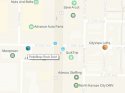
here's an image to show you what I am talking about :
You can see all those white dots, those are cell phone density map data. The brighter the white, the higher the density. You can even see where usage is high at certain points on the road. -that can be bus stops, or even crosswalks. I've gone to locations like depicted in that image just to try and understand why the data was plotting in weird spots. It was interesting when sometimes you find out a place is where people are often on a smoke break outside their work.
So.... if someone is in KC, you can get that ingress app and actually see where highest densities of pokemon spawn. I am going to guess that a coffee stop is very high density. So even without a pokestop, it's going to be a place people will often see pokemon, even if they don't know why... since it ain't a pokestop.