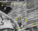
Did you see the historic pic of that "gravel pit" in 1991? I looked like it's mostly under water.
It looks like it floods a lot.
Yea, I had trouble telling what was trees and water. The images I have are poor quality.

Follow along with the video below to see how to install our site as a web app on your home screen.
Note: This feature may not be available in some browsers.


Did you see the historic pic of that "gravel pit" in 1991? I looked like it's mostly under water.
It looks like it floods a lot.
Yea, I had trouble telling what was trees and water. The images I have are poor quality.
I think the coordinates posted for the car spot were actually for the gravel pit...so I left that out. Wasn't sure which coordinates you meant to put for that...
I think so, but the only other "anomaly" remaining is how to explain what Ottojr said ... and how he fired a gun so close to a house. It does seem that 33 must be the sewage pond road as it runs directly to them. But what looks right about the position you provided is how close it is to the farm. Shew, not sure.
best guess~@45.387322, -94.692371
"Sewage Pond Road" IS CR 33!!
In my opinion.
best guess~@45.387322, -94.692371
In addition to the joint agreement signed by the Wetterlings and everyone else on 8/30/16
Proffer Agreement pursuant to plea agreement to DH from US DOJ signed by DH and his attorneys 9/1/16
http://stmedia.startribune.com/documents/1wett070916.doc.pdf
Final Plea Agreement 9/6/16 - signed by DH, his attorneys, US attorneys
https://www.documentcloud.org/documents/3099001-Danny-Heinrich-Plea-Agreement.html
There should be a 4th agreement somewhere.
I think so, but the only other "anomaly" remaining is how to explain what Ottojr said ... and how he fired a gun so close to a house. It does seem that 33 must be the sewage pond road as it runs directly to them. But what looks right about the position you provided is how close it is to the farm. Shew, not sure.
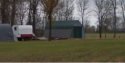
That is not a house. It's a garage. The other buildings (maybe even that garage) were not there in 10/22/1989. Granite Creations (nearest building to the East) was also not there.
Yes. The Stearns County Prosecutor signed off on the agreement and represented the State of Minnesota. The state was a party to the deal and is bound by it.Unless I missed something, these agreements appear to only apply to federal prosecutions. Is there something that says the State cannot prosecute him?
As investigators dug, Jerry and Patty Wetterling watched for a short time from afar.
Conditions werent ideal. Cows tried to chase off investigators. And the flood-prone creek that ran through the pasture made sifting through the soil more difficult.
It took hours hours to find the spot first and then hours to continually excavate, Bechtold said.
Though Heinrich said he had buried the boy in a shallow grave about 2 feet deep, and had placed Jacobs jacket on top of the remains, the evidence authorities found was scattered across at least 10 square feet, Bechtold said, a sign of erosion and moving soil from frost heaves and flooding.
http://www.startribune.com/finding-jacob-the-final-push/393005001/
Honestly, looking back on how things were back in 1989, a couple of gun shots would be an issue.
I don't hunt but, I have friends that do, and isn't fall deer hunting season?