RedHaus
Well-Known Member
- Joined
- Dec 13, 2020
- Messages
- 829
- Reaction score
- 6,627
This may be premature, but perhaps its time we take a little inventory of possible answers to @sundaaaay's question, based on our near 100 pages of discussion. So let me take a stab at summarizing where we are, sparing all the data that may or may not support each possibility.
IMO these are possible answers:
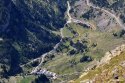
1. Hiking Accident or Drowning 11/22 - instant fatality or perished from injuries before rescued, in any of the following locations:
A. Between meeting with skier on Pic de S, the summit of Pic de S, or her subsequent decent to Port de V (very small area)2. Hiking Accident or Drowning 11/23 or 11/24 - instant fatality or perished from injuries before rescued, in any of the following locations:
B. Between Port de V and her van in Banasque if she decided to abort her adventure that day (e.g. hunger, thirst, belly ache)
C. Between Port de V and Refuge de V (very small area) at either:
i. 4:30/5:30pm if she summitted Pic de S, orD. Between Refuge de V and Hospice de France OR Chemin de l'impératrice (depending on clockwise or anti-clockwise loop)
ii. 3:30/4:00pm if she did not re-summit Pic de S
A. Between Refuge de V and Hospice de France or Chemin de l'impératrice (depending on clockwise or anti-clockwise loop)3. Perished in her Sleep due to Hypothermia while bivoacing 11/22 or 11/23, in any of the following locations:
B. Between H de F or C de L'i if she made it to either location for the night of 11/22
C. Between H de F and Bagneres du Luchon if she in fact did pursue an alternative route that the 70 year old hiker "heard" (see image below)
A. Between Port de V and her van in Banasque if she decided to abort but too late to hike back to her van4. Voluntary Disappearance 11/22-11/24 (aka could still be alive), via three possible routes:
B. Between Refuge de V and H de F or C de l'i (depending on clockwise or anti-clockwise loop)
C. Between H de F or C de L'i if she made it to either location for the night of 11/22
D. Between H de F and Bagneres du Luchon if she in fact did pursue an alternative route that the 70 year old hiker "heard" (see image below)
A. via road(s) out of Banasque5. Involuntary Disappearance 11/22-24 (abduction, kidnapping, murder), likely near civilization rather than in high country, in these areas:
B. via road(s) out of H de F
C. via road(s) out of B du L
A. Banasque if she descended to return to her van aborting (11/22 or 23) or ending as planned (11/24) her adventureOK - I put these out there from the best of my ability to assimilate everyone's thinking so far...
B. Bagneres du Luchon if she in fact pursued that alternative route that the 70 year old hiker "heard"
Is it premature to inventory possibilities like this? Are any possibilities missing? And if we're ready to digest further, which of these resonate more than others?
Thanks to @Ruthbullock pointing out the map I attached to this post from earlier this evening was from an unreliable source (DM), I would like to replace the map I used to illustrate possible routes with this new one I constructed based on Ruthbullock's version. I think this will help many of us visualize the possibilities I outlined.