Now it’s our turn here on the west coast! A “Bomb cyclone” is expected to hit the Pacific Northwest and Northern California this week. We’re hunkering down near Medford OR and expecting the infamous Siskiyou Summit on Interstate 5 to close, as it often does during the winter.
A powerful “
bomb cyclone” will combine with an atmospheric river to unleash over a month’s worth of rain, hurricane-force wind gusts and feet of mountain snow to parts of the Pacific Northwest and Northern California.
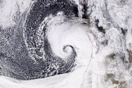
A storm system off the Pacific Northwest is expected to rapidly intensify on Tuesday in a phenomenon called “bombogenesis” and earn it the moniker of “bomb cyclone.” It will intensify so much so quickly that it could become a “triple-bomb,” tripling the criteria needed to be considered a bomb cyclone, the National Weather Service in San Francisco said.
Bomb cyclones are formidable and unload
heavy snow and strong winds during the winter. This one could be among the most intense on record for its location, a storm that occurs only “about once every ten years,” and will generate “some of the strongest winds we have seen in several years” that churn up “very dangerous mountainous seas of 30 to 35 feet,” the National Weather Service in Medford, Oregon, said.
The storm will strengthen so fast that it will fit into a special category of weather terminology known as a
bomb cyclone. A storm, or cyclone, is essentially a giant spinning vacuum in the atmosphere. When a storm's central pressure drops 0.71 of an inch of mercury inches (24 millibars) or more in 24 hours or less, it is considered to be a bomb cyclone.
"This storm's central pressure is forecast to crash from 29.53 inches (1000 mb) to at least 28.05 inches (950 mb) in 24 hours, which is double the criteria for a bomb cyclone," AccuWeather Senior Meteorologist Heather Zehr said.
A powerful winter storm brewing near the Pacific Northwest known as a bomb cyclone is dragging an atmospheric river.
www.redding.com