Great minds think alike #1 is pipeline cut. #2 is old RR track. #3 residence 1407 Gairloch Rd . It is hwy 289. You can see old logging roads (I didn't know what they were at first) but they almost surround that area of the house. There are also open like Meadow areas between dense forest.


You are using an out of date browser. It may not display this or other websites correctly.
You should upgrade or use an alternative browser.
You should upgrade or use an alternative browser.
CANADA Canada - Jack, 4 & Lilly Sullivan, 6, Vulnerable, wandered from home 10am, Gairloch Rd, Landsdowne Station, Pictou County, NS, 2 May 2025 #5
- Thread starter Unalienable Rights
- Start date
- Status
- Not open for further replies.
- Joined
- Feb 2, 2017
- Messages
- 13,485
- Reaction score
- 91,222
Lately, a lot of people seem to be leaning toward the theory that the kids might still be alive but personally, the longer they remain missing, the more likely it seems that they’re no longer with us. I can’t think of any case with 2 kids missing this long that hasn’t ended in tragedy or just never being found.
One theory going around is that MBM arranged to have the children taken. But that raises questions.
If she wanted to leave Daniel why would she need to go to such an extreme and secretive length? Was Daniel extremely abusive and she felt desperate or scared? If that were the case it seems odd that Daniel has consistently supported her story from day one. He even claims to have seen Lilly just 20 minutes before the kids disappeared if that’s true and he was in bed with MBM at the time how could she have orchestrated a hand off of the children without him noticing?
Another theory floating around is that someone “bought” the kids or took them over a drug debt. This sounds more like a dramatic movie plot than something that actually happens in real life. While child trafficking and exploitation are real the idea that someone would purchase or abduct children to settle a debt especially in a case with this much attention is incredibly far-fetched and not supported by typical trafficking patterns or real world examples. Mostly teenagers are trafficked in Nova Scotia using the lover boy method.
I’m just really struggle to believe that someone has these kids and is keeping them alive. And if someone was in on the plan holding the children wouldn’t they have came forward by now? I think people are holding on hope they are alive but realistically it just seems so impossible to me.
Also during the press conference with the RCMP they stated the search would be "scaled back" after six days, with police saying the likelihood the children are alive is "very low." So they did indicated early on they don’t think these kids are alive.
That reference to the likelihood being very low of the children found alive was with respect to being lost in the woods. That was the only theory they spoke about at that time, since then they’ve broadened their scope to consider all options. However the recent CBC interview acknowledged this is still a missing persons investigation.
If the children were placed with another caregiver, I agree with you, I’d be very surprised if the reason was because DM was abusive and she needed to get away, and even more that the children were sold.
If they were given with her consent, the only reason that makes sense to me is she was completely overwhelmed with the responsibility of two ‘possibly autistic’ children plus an 16 month old, especially if she’d already decided to separate from DM and make a go of it as a single mother. Very similar to the reason a mother gives a child for adoption, it’s out of kindness and consideration to give that child a chance of a better life and more opportunities.
We don’t know how serious was the Child Welfare situation but she may’ve been fearful or paranoid the children would be taken from her and placed in a foster home without her involvement. My theory is somebody whom the children recognized picked them up that morning, waiting in a vehicle in the yard. Why has the truth not come out? The onus would be on MBM to speak up, not the caregivers who are staying loyal to their commitment to her.
JMO
Last edited:
There is the possibility that the kids slipped out through the front door. Someone asked upthread if they even had access out the front. They do. (see below)
Lansdowne station, n.s.
Published May 5, 2025Updated May 6, 2025
Report an editorial error
Report a technical issue
Editorial code of conduct


Two young Nova Scotia children still missing from remote wooded community in Pictou County
Lindsay JonesLansdowne station, n.s.
Published May 5, 2025Updated May 6, 2025
Report an editorial error
Report a technical issue
Editorial code of conduct
Related stories
Still no evidence that missing Nova Scotia children were kidnapped, RCMP say
Nova Scotia offers $150,000 reward for information about missing siblings
Missing Nova Scotia children were assessed by child welfare agency months before disappearance
- Joined
- Aug 10, 2017
- Messages
- 94
- Reaction score
- 857
Right from the beginning, I felt her mom was part of this. Is it possible the kids are on the reservation? Does her mom live on the reservation? Please correct me if I am wrong, but reservations are governed in different ways. Is it possible the kids are on the reservation with family or extended family that are unaware they are missing ? Maybe the 'family' is trying to protect the children? I am not sure of laws on reservations- maybe they feel they do not HAVE to return the children?
- Joined
- Jun 26, 2023
- Messages
- 2,131
- Reaction score
- 14,994
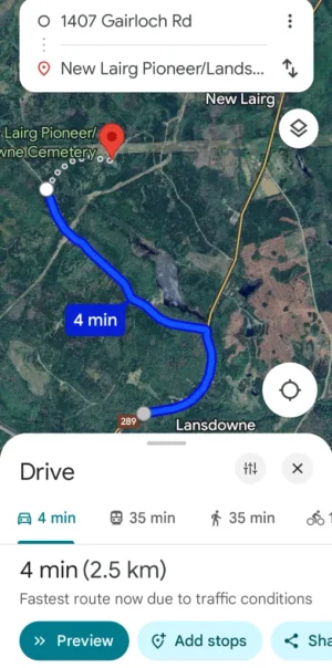
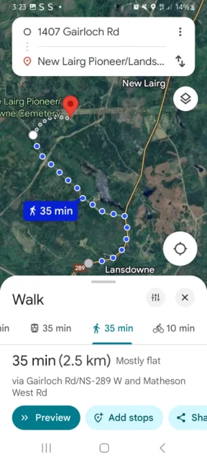
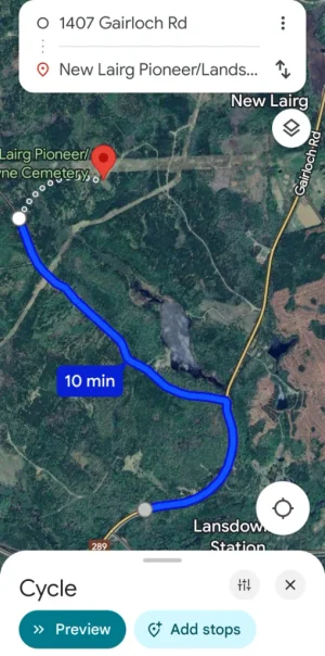
And a graveyard is within 4 minutes by car and 35 mins walking and 10 mins on a bike through the forest at the back of the house .To me that would be a stalker who was intent on getting those two kids. Premeditated for two little kids? Nah.
Beside, I don't know where everyone is looking but the train tracks are much further away to the east? And the pipe line cut is also much further north of the property on the other side of dense forest... Goggle 1407 Gairloch Rd and look at topography and distances. I don think there is a trail back there, only a logging road that starts to the east of the Hwy from house. And you can not see the house from the old RR line. Maybe I'm looking at the wrong map??
I do notice there is lots of bodies of water in the map shown are they lakes or man-made water structures from the recreational facility up the road for fishing etc
All photos google maps
Attachments
Last edited:
That reference to the likelihood being very low of the children found alive was with respect to being lost in the woods. That was the only theory they spoke about at that time, since then they’ve broadened their scope to consider all options. However the recent CBC interview acknowledged this is still a missing persons investigation.
If the children were place with another caregiver, I agree with you, I’d be very surprised if the reason was because DM was abusive and she needed to get away, and even more that the children were sold.
If they were given with her consent, the only reason that makes sense to me is she was completely overwhelmed with the responsibility of two ‘possibly autistic’ children plus an 16 month old, especially if she’d already decided to separate from DM and make a go of it as a single mother. Very similar to the reason a mother gives a child for adoption, it’s out of kindness and consideration to give that child a better life and more opportunities.
We don’t know how serious was the Child Welfare situation but she may’ve been fearful the children would be taken and placed in a foster home without her involvement. My theory is somebody whom the children recognized picked them up that morning, waiting in a vehicle in the yard. Why has the truth not come out? The onus would be on MBM to speak up, not the caregivers who are staying loyal to their commitment to her.
JMO
dbm
- Joined
- Feb 2, 2017
- Messages
- 13,485
- Reaction score
- 91,222
And yet, the questions they supposedly asked Daniel in the polygraph test were about Lilly and Jack's deaths.
This case is so confusing.
If DM was involved in the children’s disappearance in any way, wouldn’t that he might’ve murdered them be #1 on the list? The RCMP did say they were investigating all options. Just because they ask questions during an investigative interview doesn’t mean they know the answers. DM didn’t say he was being accused, just that they asked the question.
JMO
Last edited:
And a graveyard is within 4 minutes by car and 35 mins walking and 10 mins on a bike through the forest at the back of the house .
I do notice there is lots of bodies of water in the map shown are they lakes or man-made water structures from the recreational facility up the road for fishing etc
All photos google maps
Holy crap. Good find Su5ie!
And a graveyard is within 4 minutes by car and 35 mins walking and 10 mins on a bike through the forest at the back of the house .
I do notice there is lots of bodies of water in the map shown are they lakes or man-made water structures from the recreational facility up the road for fishing etc
All photos google maps
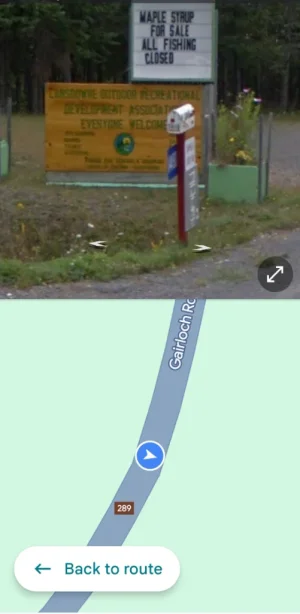
Hi Su5ie, What are we looking at in picture #4. Is it a sign for the boneyard?
- Joined
- Feb 2, 2017
- Messages
- 13,485
- Reaction score
- 91,222
Hi Su5ie, What are we looking at in picture #4. Is it a sign for the boneyard?
It’s Pic #3
The sign in pic #4 is for a Lansdowne Recreational Development.
- Joined
- Jun 26, 2023
- Messages
- 2,131
- Reaction score
- 14,994
In picture 4 it is the recreational business a couple of kilometers up the road from the kids home it's on the opposite side of the road .Hi Su5ie, What are we looking at in picture #4. Is it a sign for the boneyard?
If you turn left out of the driveway of Daniels property and continue on it is on the right hand side
- Joined
- Jun 26, 2023
- Messages
- 2,131
- Reaction score
- 14,994
RV is spotless imo in that photoThere is the possibility that the kids slipped out through the front door. Someone asked upthread if they even had access out the front. They do. (see below)
Two young Nova Scotia children still missing from remote wooded community in Pictou County
Lindsay Jones
Lansdowne station, n.s.
Published May 5, 2025Updated May 6, 2025
Report an editorial error
Report a technical issue
Editorial code of conduct
Related stories
Still no evidence that missing Nova Scotia children were kidnapped, RCMP say
Nova Scotia offers $150,000 reward for information about missing siblings
Missing Nova Scotia children were assessed by child welfare agency months before disappearance
View attachment 597748
Re: Backyard. There is another dwelling on the property with direct access to the backyard. Someone who was in that RV could have noticed the children unattended and removed them from the property. We have no idea who was in that RV that morning - if anyone - because it has never been discussed by DM. But I don't think these potential suspects should be overlooked just because DM hasn't mentioned them.Which leaves lost in woods or abducted (from backyard makes zero sense, from front yard is possible, but makes zero sense for a4&6 yr old to leave the play area in back to nothing infront)
Hypothetically, if someone from the RV took these kids that morning, that aligns 100% with both DM and MBM's version of the events, and could explain why MBM left and her mother made accusations. It could also explain their ongoing silence, as they have very strong suspicions about who is responsible, but no proof. It could explain why DM has been focused on proving his innocence, while at the same time being vague about the circumstances.
- Joined
- Jun 26, 2023
- Messages
- 2,131
- Reaction score
- 14,994
First 3 photos are behind Daniels property and just the different times it would take to get to the graveyard on the map using different options. So walking ,car , cyclingIt’s Pic #3
The sign in pic #4 is for a Lansdowne Recreational Development.
I’m unable to see either a rail line or the pipeline clearance directly behind the Martell residence. If there was anything there at one time, it’s now overgrown with trees and bush. The landscape behind appears to be as heavily forested as that across the road. Are we all looking at the same Google Map image?
My understanding is the old rail line runs close to Landsdowne Station, a bit of a distance away. An old rail bed or reference to a pipeline ‘trail’ is somewhat misleading, as it offers an image of maintained pathways meant for recreational use. During the Apr 30- May 1st searches it was clarified by the media that is not so.
View attachment 597739
I don't know about right behind the house, but I think there is an old rail line at the very bottom of your screenshot. If you use Google Streetview (the little orange guy) and walk him along Gairloch Rd to the southwest of the house as you have marked it, you can see where the rail line crosses. It is after Lansdowne Station Rd, but just before Lansdowne Rd. It is 500 metres from the house.
These are the coordinates for where the rail line intersects Gairloch Rd.:
45.42684, -62.82989
Google maps link: Street View · Google Maps
If the kids actually walked along Gairloch Rd (something which I think we were told they would *never* do - walk along or cross Gairloch Rd) they could have reached that rail line and then walked along it.
If you turn right off Gairloch and follow along the tracks, the rail line crosses what is being referred to as "the pipeline trail". It is only visible on google maps when you have the satellite view (not just the map). It is roughly parallel to Gairloch Rd. It runs behind the house, probably just a bit more than a kilometre back. And yes, it looks pretty dense between the house and that pipeline access trail.
Where anything I said might be construed as an opinion, it's MOO!
I noticed that as well.RV is spotless imo in that photo
- Joined
- Feb 2, 2017
- Messages
- 13,485
- Reaction score
- 91,222
In picture 4 it is the recreational business a couple of kilometers up the road from the kids home it's on the opposite side of the road .
If you turn left out of the driveway of Daniels property and continue on it is on the right hand side
New Liarg/Lansdowne Pioneer Cemetery, closed, dates from the 1700 and 1800s. The photos give the appearance of it being lovingly tended as often historical cemeteries are, but certainly it would be obvious if there were any ground disturbances, if that’s what people might be leaning towards.
Absoluterubbish
Well-Known Member
- Joined
- May 24, 2025
- Messages
- 724
- Reaction score
- 5,788
Wow this gives a whole new depth to it for me. ThanksThank you for the clarification.
CBC reported in a June 19th article that the "families" brought the emergency responders to the "piece of blanket."
I took it to mean that it was shown to first responders by the mother or step-father. Thoughts?
The only thing worse then loosing two children would be to lose three.I keep coming back to the mother leaving DM so quickly, and then blocking him and cutting off contact. It just feels as if "there is something there" there. I feel that separation is significant in this case. I just cannot figure out HOW.
Also, I am now suspicious of how DM made the statement about (I'm paraphrasing) "Leave MBM alone, her mental health is important, it affects her ability to care for our child." On one hand, this could be seen as a normal, empathetic, compassionate thing for a partner to say. HOWEVER, it can also be seen as something someone would say to lessen the chances of their accomplice "cracking" and spilling the beans? What if DM is doing all the talking because he is AFRAID if MBM doing any talking?
I do not believe that either parent murdered those two children, however something happened between the last afternoon they were seen and the morning that they are responsible for and charges plus also losing Meadow has led them on this journey.
Neither will betray each other however Malayha is in deep mourning and struggling.
I absolutely cannot say for certain but a few scenarios I've thought about
1. Parents drove home and when they arrived kids were asleep. They left them in car with engine running. Found them deceased
2. Children got into drugs left around by parents, am thinking they may have picked up drugs in Lillys backpack, possibly why that has disappeared.
3. Mom is completely overwhelmed with 2 quite active possibly Autistic children and a toddler. As per Bio dads mom, things were completely different when she last saw children. She was a great Mom and everything was neat and clean. When she left she also lost her support, now no support and unable to cope maybe they sought other means to calm the children. Maybe they researched sleep aids for kids, maybe autism drugs you can order on line or from a friend.
Whatever the cause, they panicked, disposed of the bodies.
Telling the truth at this point really would certainly lead to jail and removal of Meadow.
Unless they find the bodies there is no proof of anything. Malayha not speaking is easiest way to offer any hints. No communication from Daniel prevents him from blurting anthing out
MOO
- Joined
- Feb 2, 2017
- Messages
- 13,485
- Reaction score
- 91,222
I don't know about right behind the house, but I think there is an old rail line at the very bottom of your screenshot. If you use Google Streetview (the little orange guy) and walk him along Gairloch Rd to the southwest of the house as you have marked it, you can see where the rail line crosses. It is after Lansdowne Station Rd, but just before Lansdowne Rd. It is 500 metres from the house.
These are the coordinates for where the rail line intersects Gairloch Rd.:
45.42684, -62.82989
Google maps link: Street View · Google Maps
If the kids actually walked along Gairloch Rd (something which I think we were told they would *never* do - walk along or cross Gairloch Rd) they could have reached that rail line and then walked along it.
If you turn right off Gairloch and follow along the tracks, the rail line crosses what is being referred to as "the pipeline trail". It is only visible on google maps when you have the satellite view (not just the map). It is roughly parallel to Gairloch Rd. It runs behind the house, probably just a bit more than a kilometre back. And yes, it looks pretty dense between the house and that pipeline access trail.
Where anything I said might be construed as an opinion, it's MOO!
Thanks for your explanation. After that last weekend search the beginning of June, it was stated 8.5 sq km around the residence had been searched. That’s a lot of ground covered and would’ve included any open area within that parameter.
But I’m not in the camp of a hiking abductor lurking around for an opportunity, overgrowth, bush, black flies and all. JMO
Last edited:
- Status
- Not open for further replies.
Similar threads
- Locked
- Replies
- 984
- Views
- 75K
- Locked
- Replies
- 1,031
- Views
- 69K
- Locked
- Replies
- 1,096
- Views
- 99K
- Locked
- Replies
- 1,030
- Views
- 99K
Guardians Monthly Goal

Goal Reached! We hit our target of 75 new Guardians!
New stretch goal: 100!
Our goal for the month is 75 new Guardians members to sign up. Have you been thinking about becoming a member?
Click here to find out how!
Online statistics
- Members online
- 100
- Guests online
- 2,046
- Total visitors
- 2,146
Totals may include hidden visitors.
Forum statistics
Community Rules
-
Be CivilTreat all members with respect. No personal attacks, harassment, or inflammatory language.
-
Victim FriendlyAlways show respect for victims and their families. No victim blaming or insensitive speculation.
-
Fact-based SourcingProvide credible sources for claims. Distinguish between verified facts and personal theories.
-
Social Media UseDo not post direct links to personal social media profiles of private individuals.
-
Copyright and PaywallsDo not copy full articles. Summarize and link to the original source instead.
-
Privacy and Personal InformationDo not post personal information such as addresses, phone numbers, or workplaces.
-
Registered Sex-OffendersDo not name or speculate about RSOs unless officially named in connection to a case.
-
Stay On TopicKeep discussions relevant to the case or topic at hand. Avoid off-topic tangents.
-
Accounts, Moderation, and DisputesOne account per person. Contact moderators privately for disputes or concerns.
-
Solicitation and FundraisingNo solicitation, fundraising, or promotion of personal ventures without approval.