

- Joined
- Jun 20, 2011
- Messages
- 127
- Reaction score
- 1,335
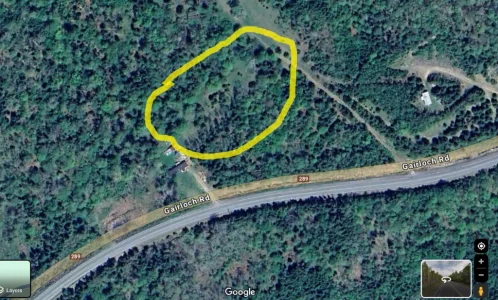
Cut to emphasize: I thought I saw on one of the maps that the area between their home and access to the dirt road going toward the pipeline clear-cut is NOT entirely forested. It may have been an older image, though, but to me, from above it looked more like an area that would be overgrown with high grasses and maybe short shrubs, or perhaps it is a periodic wetland with that kind of lower growth.There is a bootprint and a scrap of blanket found near the pipeline trail, someone in the family identifies it as being from Lilly’s blanket. Yet the terrain between the home and the pipeline trail is too dense for the children to have been likely to get through to make it to the pipeline trail.
Yes, it looks like one can get to the pipeline cut by walking through dense forest from their house, but I can also imagine their outings (I think DM mentioned that, as well as going to the "cabins") - especially on 4-wheelers - being through more grassy or slightly wet areas, if such areas really do exist.
I'll see if I can find an image here in the threads. As I recall, it had Gairloch Road running somewhat horizontally, the pipeline cutting a (obviously unnatural) line from upper right toward mid-left, and a lighter patch of maybe 2-3 football fields in size just to the right and slightly up from the house, with a faint dirt track running lower right toward mid-view.
Judy
Edited to include photo, with possible "brushy area" circled by me. The photo is a screenshot from Google Earth, but I don't know how recent it is. That view could have been PRIOR to the hurricane.
Attachments
Last edited:
")

